|
||

|

|
|

|
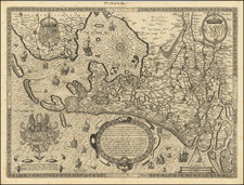
Interesting map of Germany during the Roman Empire. Extends from Paris to Warsaw and Denmark to Italy, showing the many cities established by the Romans, along with battle sites, vignettes of various other battles and other inigenous scenes and a host of other details. Embellished with 3 large decorative cartouches. An interesting historical map. A lively decorative map illustrating an interesting early period of Northern and Central Europe..
Matthäus Seutter (1678-1757) was a prominent German mapmaker in the mid-eighteenth century. Initially apprenticed to a brewer, he trained as an engraver under Johann Baptist Homann in Nuremburg before setting up shop in his native Augsburg. In 1727 he was granted the title Imperial Geographer. His most famous work is Atlas Novus Sive Tabulae Geographicae, published in two volumes ca. 1730, although the majority of his maps are based on earlier work by other cartographers like the Homanns, Delisles, and de Fer.
Alternative spellings: Matthias Seutter, Mathaus Seutter, Matthaeus Seutter, Mattheus Seutter