This item has been sold, but you can enter your email address to be notified if another example becomes available.


|
||

|

|
|

|
Stock# 69857
Description
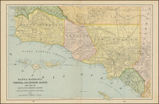
Highly detailed route map of the Pacific Electric Railway, published in 1912.
The present examples shows two primary lines, showing:
- Orange Empire Trolley Trip, from Los Angeles to Redlands and Riverside
- Mt. Lowe Trip, via Pasadena and Rubio Canyon.
A fascinating depiction of Southern California during the high point of light rail transportation. Hundreds of train stops shown, along with many towns that either no longer exists or which have been absorbed by neighboring cities.
Several photos show the Mt. Lowe Alpine Tavern & Resort and the based of the Mt. Lowe incline between Rubio and Echo Mountain.
On the verso are two color illustrations (covers) and details on the Riverside, San Bernardino and Redlands.
![[Monterey] Plan De La Baie De Monterey Situee Dans La Californie Septentrionale . . .](https://storage.googleapis.com/raremaps/img/small/99008.jpg)