|
||

|

|
|

|
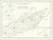
Detailed sea chart of the easternmost tip of the Arabian Peninsula in present-day Oman. Interestingly, the map was made from surveys of the Indian Navy in 1849.
Muscat is shown towards the top of the map. Hundreds, if not thousands, of soundings dot the map.
The following inset maps are included on the chart:
Bandar Jissa
Sur Anchorage From a French Government Survey, 1901
Bandar Khairan
Madraka Anchorage
Khor Jarama
Dar Sait Anchorage Sketch Survey by Lieut. H.T. Bowen, H.M.S. Alert, 1910.
The Oman and Zanzibar Virtual Museum includes the following description of the original chart:
The survey was carried out by Commander Sanders and Lieutenant Grieve who were in the employ of the Indian Navy. In 1840 the British had taken control of the port of Aden; a strategically important port along the trade route from England to India. From their base at Aden the British began to steadily grapple with the problem of piracy that had been plaguing much of British shipping. In order to achieve this they required the most up-to-date hydro-graphic information, hence the significant increase in the charting of the region by the likes of Sanders, Grieve, Carless, and Moresby; In fact by the middle of the nineteenth century the whole of the Arabian Peninsula had been surveyed. The Indian Navy was the naval arm of the East India Company. It had been established by the Company as early as 1612 when it protected the their nascent commercial interests. In 1686 with most of the English commerce moving to Bombay the navy was renamed 'The Bombay Marine'. A name that it would keep for the next 144 years, until in 1830, it was renamed the 'Her Majesty's Indian Navy'. This title would, however, not be so long lived and in 1858, when the EIC was released of its administration of India the navy was brought under the control of the British State.
The British Admiralty has produced nautical charts since 1795 under the auspices of the United Kingdom Hydrographic Office (HO). Its main task was to provide the Royal Navy with navigational products and service, but since 1821 it has also sold charts to the public.
In 1795, King George III appointed Alexander Dalrymple, a pedantic geographer, to consolidate, catalogue, and improve the Royal Navy’s charts. He produced the first chart as the Hydrographer to the Admiralty in 1802. Dalrymple, known for his sticky personality, served until his death in 1808, when he was succeeded by Captain Thomas Hurd. The HO has been run by naval officers ever since.
Hurd professionalized the office and increased its efficiency. He was succeeded by the Arctic explorer Captain William Parry in 1823. By 1825, the HO was offering over seven hundred charts and views for sale. Under Parry, the HO also began to participate in exploratory expeditions. The first was a joint French-Spanish-British trip to the South Atlantic, a voyage organized in part by the Royal Society of London.
In 1829, Rear-Admiral Sir Francis Beaufort was appointed Hydrographer Royal. Under his management, the HO introduced the wind force scale named for him, as well as began issuing official tide tables (1833). It was under Beaufort that HMS Beagle completed several surveying missions, including its most famous voyage commanded by Captain FitzRoy with Charles Darwin onboard. When Beaufort retired in 1855, the HO had nearly two thousand charts in its catalog.
Later in the nineteenth century, the HO supported the Challenger expedition, which is credited with helping to found the discipline of oceanography. The HO participated in the International Meridian Conference which decided on the Greenwich Meridian as the Prime Meridian. Regulation and standardization of oceanic and navigational measures continued into the twentieth century, with the HO participating at the first International Hydrographic Organization meeting in 1921.
During World War II, the HO chart making facility moved to Taunton, the first purpose-built building it ever inhabited. In 1953, the first purpose-built survey ship went to sea, the HMS Vidal. Today, there is an entire class of survey vessels that make up the Royal Navy’s Hydrographic Squadron. The HO began to computerize their charts in the late 1960s and early 1970s. In 1968, the compilation staff also came to Taunton, and the HO continues to work from there today.
![[ Medina, Saudi Arabia ] Medine](https://storage.googleapis.com/raremaps/img/small/97808.jpg)