


|
||

|

|
|

|
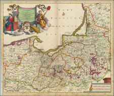
An Extremely Rare English Chart of the Baltic Coasts of Estonia, Latvia, and Lithuania.
A wonderful rarity from the early days of English sea chart publication, being one of the maps that John Seller produced using copper plates bought from the Dutch as scrap metal.
The chart stretches from the Gulf of Finland at the west (north) to Klaipėda at the right (south). Seller has reworked the title block adding his own English title and his name, along with his title as "Hidrographer to the Kings most Excellent Majesty". Below that the original French subtitle remains. Seller has also erased the original scale bar and replaced it with "A Scale of English Leagues 20 to one degree". Some of the toponyms and notes on the map are now in English, apparently changed from the original.
Seller's 1671 English Pilot. The First Book... Northern Navigation...
In 1671, in an attempt to rebound from his 1662 imprisonment for treason and his recent appointment as Hydrographer to the King, John Seller purchased the copper plates used by Janssonius for his pirate version of the Light der Zeevaert to be reworked and published as a new chartbook the English Pilot. The First Book... In many ways this process marked the beginning of a general shift towards the British map trade supplanting the Dutch, though it would not be fully realized until the 18th century.
The practice of reusing old plates as his own earned him heaps of scorn from contemporary mapmakers. From Laurence Worms's essay on Seller and Pepys we have the following illustrative anecdote:
Because, in a way, Pepys was sick all over Seller. It is on this voyage that we first hear the central charge, the crux of this long-standing accusation of dishonesty and plagiarism. It was en route to Tangier that the military engineer, Thomas Phillips, tells Pepys that Seller had produced his first maritime atlas, the English Pilot, from “old worn Dutch copper plates” bought “for old copper” – for scrap – and had simply issued “the very same platts … without a Dutch word so much as altered” in his “pretended new book”.
On this plate see a number of English words within the map image himself, so perhaps the last charge is not exactly correct.
The Wardington Sale Catalogue includes the following note on the 1671 English Pilot (that copy being the last to appear on the market - selling for £42,000 in 2006):
John Seller conceived the English Pilot as a rival to similar Dutch publications. It was the first English sea-atlas to enter a field in which the Dutch had a virtual monopoly, and is an important landmark in English chart- and map-publishing.
The majority of the plates are printed from Dutch sea-charts crudely re-engraved to appear English in origin. The plates were prepared by Johannes Janssonius and were pirated in turn from Willem Blaeu, whose atlas was published in 1608. Although the use of outdated Dutch plates has sparked a certain amount of moral outrage from later commentators, and also contemporaries such as Pepys, it is worth pointing out that the first Blaeu terrestrial atlases were based around existing plates acquired from another publisher, and several other Dutch and English publishers went on to build successful businesses in the same way, so Seller was by no means exceptional in seeking a shortcut route to compiling an atlas, while the additional suite of charts prepared by Seller is a valuable contribution to the mapping of these coasts. Perhaps, if he had not been so unsuccessful, history would give him far greater credit than he has received so far.
The First Book (Northern Navigation) was first advertised in the London Gazette for 24th-27th April 1671, and in the Term Catalogues for Easter Term 1671 (licensed on 30 May), with the price given as 12 shillings bound. The Second Book (Southern Navigation) was advertised in the Term Catalogues for Hilary Term 1672 (licensed on 7th February), with the price apparently given as 14 shillings bound.
Rarity
According to Phillips Atlases 3985, this map appears as chart number 24 in the 1671 English Pilot. That atlas was last for sale in the Wardington Collection in 2006.
John Seller was one of the most notable map and instrument makers in England in the late-seventeenth century. He was especially known for the sea charts, many of which featured in his influential English Pilot and Atlas Maritimus. Seller was born in London in 1632. His father was a cordwainer and John was apprenticed to Edward Lowe, of the Merchant Taylors’ Company. He was made free of that company in 1654. Later, he also was made a brother of the Clockmakers’ Company, which housed several instrument makers. He started business as a compass maker but expanded his offering to include navigational instruments and charts.
Seller’s career was halted temporarily, and fantastically, when he was tried for high treason in 1662. He was accused of involvement in a plot led by Thomas Tonge. While Seller likely only unwisely repeated rumors, he was convicted. The other conspirators, who did admit some degree of guilt, were executed, but Seller maintained his innocence and, via insistent petitions, he eventually secured his release from Newgate Prison.
This episode did not seem to slow Seller’s rise too much, however. Seller was granted a royal license to publish English-language maritime atlases. This gave him a near-monopoly and led to his being named hydrographer to the King in 1671. Although the point of the project was to produce English charts of Dutch dominance and bias, Seller ended up using many Dutch plates as his base material. The first volume of The English Pilot was published in 1671, followed by more volumes as well as The Coating Pilot (1672) and the Atlas Maritimus (1675). Seller was commercially successful, but some of his projects required further support. The English Pilot was eventually taken over by John Thornton and William Fisher, for example, and his proposed English atlas only produced maps of six counties.
Seller’s sons, John and Jeremiah, followed in their father’s profession. Seller also apprenticed several promising young men, including Charles Price, with whom his sons partnered. Through Price, Seller can be seen as the founding figure of an important group of London mapmakers that included Price, John Senex, Emanuel Bowen, Thomas Kitchin, and Thomas Jefferys.
![[ Holy Roman Empire ] Tavola Nuova Di Germania](https://storage.googleapis.com/raremaps/img/small/103614.jpg)
![Повстанцы 1863 Года [(Polish) Insurgents of 1863]](https://storage.googleapis.com/raremaps/img/small/52719.jpg)