|
||

|

|
|

|
Stock# 69546
Description
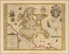
Exceptionally rare chart of the Baltic Sea and adjoining coastlines published by Caspar Lootsman (here "Casparus Loots-man") in Amsterdam.
The chart shows the Baltic Sea from Trelleborg to Rugen at the west and the easternmost section of the Gulf of Finland in the east. The map does not extend far into the Gulf of Bothnia in the north.
Stockholm is labeled, as is Riga ("Ryga"), and Tallin ("Revel").
Another edition of the plate is signed by Johannes van Loon. The plate probably went from van Loon to either Caspar's father or Caspar directly.
The chart follow in the tradition of Colom and Doncker's maps of the Baltic.
Condition Description
Original hand-color in outline. Expertly remargined at the left and right sides, just touching the neatline. On the left side a small amount of paper has been reinstated with rhumblines in facsimile just between Rugen and the southern tip of Sweden.