|
||

|

|
|

|
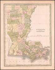
First Appearance of Cherokee Boundary and Choctaw Boundary
Fine example of this second state of Henry Schenk Tanner's spectacular map of Louisiana and Mississippi.
Drawn from Darby's remarkable map of the region and other contemporary sources, the map was the best widely published map of the region published in the early 1820s. The map is extensively annotated with specific observations regarding the regions shown.
The map was originally published in Tanner's New American Atlas, this map was periodically revised and re-issued, although these later editions are very rare on the market.
The present example retains the 1820 date, but adds a number of important early features:
Mississippi Updates
- Cherokee Boundary added
- Choctaw Boundary added
- Many new roads and post roads added throughout the state
- Jackson and Carolls Road have been added and the area around Jackson has been completely reworked, with the topographical features rivers and Indian Settlements and Agencies to the west of the Choctaw Boundary completely modified.
- Monroe County in Mississippi added, with township surveys completed -- the first in Northern Mississippi (Originally part of Marian County, Alabama Territory, until new lines of demarcation put it in the State of Mississippi in 1821)
- Columbus added in Monroe County, with several roads running through Columbus and Pitchlyn for the first time.
- Second road added, running south from Yakunnee Township and Chickama Township, in Choctaw Territory
- Alligator note is removed from confluence of Arkansas and Mississippi Rivers and Coldwater River and Tallahatchie Creek named.
- Yazoo River is completely re-worked north of the Choctaw Boundary, with Socktafatoota River and Huschpuckanah River added to the west, along with several other rivers to the east of the Mississippi River.
- Township Surveys in central Mississippi and Northern Louisiana are added.
- Covington County and Perry County Mississippi are added
- Cartographic details in Jackson County and Hancock County are complete revised
- Jacksonville in Marion County on the Pearl River is replaced on the other side of the River by New Columbia
Louisiana Updates
- The Surveyors Meridian has been added, dissecting Louisiana from North to South
- Terre Bonne Parish is added.
- Lafayette Parish is added.
- Natchitoches Parish is mostly laid out with townships
- M. Rouges Claim in Washita Parish is now outlined
- The town of Washita has been renamed Monroe in Washita Parish
- Ocatahoola Parish is now laid out in townships
An essential map for Louisiana and Mississippi Collectors.
![[Florida to New Orleans] The North Coast of the Gulf of Mexico from St. Marks to Galveston . . . 1842](https://storage.googleapis.com/raremaps/img/small/83469.jpg)