
This item has been sold, but you can enter your email address to be notified if another example becomes available.


|
||

|

|
|

|
Stock# 69339
Description
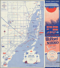
Detailed working sea chart of Miami Harbor, published by the US Coast & Geodetic Survey.
Includes a nice early town plan of Miami, and early details on Virgin Key, Key Biscayne and South Miami Beach.
The map extends north to Bal Harbor and South to Chicken Key and Key Biscayne.
Condition Description
Minor Soiling


![(Florida-Georgia) Wie der Franzosen Oberster eine Seul / daran das Wapen dess Königes auss Franckreich / aussrichten lassen. [How the French commander had a seal made, on which the coat of arms of the King of France is displayed.]](https://storage.googleapis.com/raremaps/img/small/95828.jpg)
![[ Georgia Coast ] Sex alia flumina a Gallis observata. IIII.](https://storage.googleapis.com/raremaps/img/small/97965.jpg)