|
||

|

|
|

|
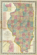
Geological Wall Map of Illinois
Fine large format Geological map of Illinois, published by Illinois State Geologist Amos Henry Worthen.
The geology of the state is broken down into 9 color codes representing Tertiary and Cretaceous, Upper Coal Measures, Lower Coal Measures and Conglomerate, Lower Carboniferous Limestone, Devonian, Upper Silurian Niagara Group, Cincinnati Group, Trenton Group, and Calciferous Group. This monumental map is the culmination of 25 years of work by the Illinois Geologists.
The first Illinois Geological Survey began in 1851, first directed by Dr. Joseph G. Norwood from 1851-1855 and later complete by Amos H. Worthen from 1858-1875. Worthen, a fossil and mineral collector who was self-taught, became one of the leading geologists of his time. As State Geologist, Worthen gathered a number of talented geologists and paleontologists to work on the Survey.
The result of the investigations of these scientists was an 8 volume set published between 1866 and 1890, containing more than 4,700 pages of text, figures and plates. The volumes include descriptions of landforms, geology of coal fields, analyses of Illinois rocks and waters, and summaries of geology county by county. Worthen's descriptions and volume of plate illustrations of 1,626 species of fossils are special features of this work. Other illustrations are detailed drawings of landscapes and geological formations, various charts, and maps.
Amos Henry Worthen
Amos Henry Worthen (1813–1888) was an American geologist and paleontologist from Illinois. He was the second state geologist of Illinois and the first curator of the Illinois State Museum. He was a fellow of the American Association for the Advancement of Science and a member of the National Academy of Sciences.
Rarity
The map is very rare on the market. Only one other example has appeared on the market in the past 20 years.
![[ Map of the Mississippi River ]](https://storage.googleapis.com/raremaps/img/small/99811.jpg)