|
||

|

|
|

|
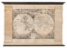
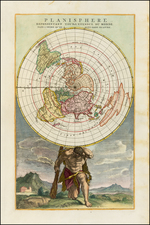
Attractive Double Hemisphere Map of the World Showcasing the Latest Discoveries in North America and the Pacific
Remarkable large format map of the World in two Hemispheres, published in Paris by A.H. Brue in 1820 and improved and augmented by Charles Picquet in 1836.
Finely-executed map of the world in two hemispheres displaying the most recent discoveries, with particularly excellent detail in North America and early depictions of Australia’s interior. The lower center section illustrates a table illustrating the world's longest rivers on the left and the world's tallest mountains on the right.
Originally issued 1820 and augmented shortly thereafter in November 1821, this rare variant edition was re-issued using the same set of copper-plates in 1836. This work was printed on five sheets, with four map sheets and the title panel as a connector, which were intended to be joined into the complete large format map.
The map is stylistically serene, with few flourishes except the elegant calligraphic script in the title and dedication cartouches to be centered between the hemispheres. The clean style of this map serves to showcase its fine cartographic elements all the more.
Originally dedicated to Baron Georges Cuvier (“The Father of Paleontology”), with a reference to Aaron Arrowsmith's world map of 1794, the dedication has been removed in this edition and replaced with the table of mountains and rivers.
The updates to the map are comprehensive and up-to-date, most notably those focused on the search of the Northwest Passage and the early discoveries along the Antarctic Coastline south of Tierra del Fuego and the "Terre d'Enderby".
Other noteworthy improvements are shown in the interior parts of Australia and the coastline of the Arctic Sea north of Canada.
The "Gd. Mount" in the Rocky Mountains is now "Gd Mount James". Austin and Texas are both now added, but "Gaboeston" (apparently Galveston), is curiously misplaced on the Trinidad River.
Rarity
The map is very rare on the market. This is the first example we have ever seen.
We note only the entry for the map in 1885, in the Catalogue de la Bibliothèque du Ministère des affaires étrangères, Volume 1 published by the Belgium Ministère des affaires étrangères. in 1878.
Andre Hubert Brué was a French geographer and cartographer. Born in Paris, he served in the French Navy, joining the Baudin expedition to the Pacific (1800-1804). After his sea service, Brué applied his navigation and charting skills to creating finely-crafted maps, which were renowned for their crisp engraving and accuracy. He drew directly on the copper of the plate, creating what he called encyprotypes. He is best known for the Atlas universal de géographie physique, politique, ancienne et moderne.
![[Volcanos and the Subterranean World] Tabula Geographico-Hydrographica Motus Oceani, Currentes, Abyssos, Montes Igniuomos In Universo Orbe Indicans, Notat Haec Fig. Abyssos Montes Vulcanios](https://storage.googleapis.com/raremaps/img/small/95720.jpg)