|
||

|

|
|

|
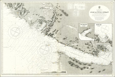
Attractive Chart Showing a Nascent City of Vancouver
This is a navigational chart of the area around the Burrard Inlet on the Salish sea. The map, comprised of several detailed inlays, extends inland to Harrison Lake. Navigational detail on the map is extensive, showing many soundings, shoals, railroads, dredged channels, banks, and much more. The map shows three inlays to complement the general map of the inlet, these are of the First Narrows, the Second Narrows, and Vancouver Harbor. Additional annotations and charts describe tides, currents, floodplains, and more. A view of Atkinson Point Lighthouse is provided.
Vancouver is shown barely reaching Stanley Park to the north and False Creek to the south. In the east, the city extends no further than Downtown Eastside. Several structures and installations are shown throughout the city, including a public school, market, sugar refinery, and furniture factory. Other towns, which have now been conurbanized, are also visible.
The map preserves the layout of Vancouver from the mid-1800s; it does not appear to have been updated in editions after 1868, though the name has been changed to reflect Vancouver's new status as a city. Vancouver had just witnessed the Fraser Gold Rush in 1858, and Vancouver would only be established in 1862. By 1867, the city had reached the Hastings Saw Mill, and that neighborhood became known as Gastown. This is the layout shown on the map, and the city would subsequently change rapidly. Granville would receive the terminus of the Canadian Pacific Railway in the 1880s, and North Vancouver would be settled soon after.
As with all British Admiralty charts, this map provides a wealth of information while preserving a simple and attractive design.
The British Admiralty has produced nautical charts since 1795 under the auspices of the United Kingdom Hydrographic Office (HO). Its main task was to provide the Royal Navy with navigational products and service, but since 1821 it has also sold charts to the public.
In 1795, King George III appointed Alexander Dalrymple, a pedantic geographer, to consolidate, catalogue, and improve the Royal Navy’s charts. He produced the first chart as the Hydrographer to the Admiralty in 1802. Dalrymple, known for his sticky personality, served until his death in 1808, when he was succeeded by Captain Thomas Hurd. The HO has been run by naval officers ever since.
Hurd professionalized the office and increased its efficiency. He was succeeded by the Arctic explorer Captain William Parry in 1823. By 1825, the HO was offering over seven hundred charts and views for sale. Under Parry, the HO also began to participate in exploratory expeditions. The first was a joint French-Spanish-British trip to the South Atlantic, a voyage organized in part by the Royal Society of London.
In 1829, Rear-Admiral Sir Francis Beaufort was appointed Hydrographer Royal. Under his management, the HO introduced the wind force scale named for him, as well as began issuing official tide tables (1833). It was under Beaufort that HMS Beagle completed several surveying missions, including its most famous voyage commanded by Captain FitzRoy with Charles Darwin onboard. When Beaufort retired in 1855, the HO had nearly two thousand charts in its catalog.
Later in the nineteenth century, the HO supported the Challenger expedition, which is credited with helping to found the discipline of oceanography. The HO participated in the International Meridian Conference which decided on the Greenwich Meridian as the Prime Meridian. Regulation and standardization of oceanic and navigational measures continued into the twentieth century, with the HO participating at the first International Hydrographic Organization meeting in 1921.
During World War II, the HO chart making facility moved to Taunton, the first purpose-built building it ever inhabited. In 1953, the first purpose-built survey ship went to sea, the HMS Vidal. Today, there is an entire class of survey vessels that make up the Royal Navy’s Hydrographic Squadron. The HO began to computerize their charts in the late 1960s and early 1970s. In 1968, the compilation staff also came to Taunton, and the HO continues to work from there today.
![[ Pacific Northwest - Northwest Passage ] Limes Occidentis Quivira et Anian. 1597](https://storage.googleapis.com/raremaps/img/small/71207.jpg)
![[ Prince Frederick Sound, Ketchickan, Queen Charlotte's Island & Stitka ] Cote Nord-Ouest de l'Amerique reconnue par Cape. Vancouver IVe. Partie . . .](https://storage.googleapis.com/raremaps/img/small/90995.jpg)
![[Alaska, Northwest Coast and North Pacific Ocean] Der Noerdliche Theil des Grossenwelt Meeres . . . 1804](https://storage.googleapis.com/raremaps/img/small/80463.jpg)