


|
||

|

|
|

|
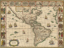
Scarce Variant of Blaeu's Map of the Americas
This is a decorative example of Blaeu's map of America, one of the most sought after maps of the continent from the Golden Age of Dutch Cartography. The map blends contemporary geographical knowledge with a rich artistic image. Blaeu's maps set the standard for quality maps of the period, with exceptional engraving, paper, color, and design.
The map includes a magnificent peninsular California with the northwest coast of America nearly aligned with the 40th parallel. Over thirty place names appear on the peninsula. The map also includes an unusual east coast of North America, packed full of placenames, including Chesapiooc (Chesapeake), Sanawanook, Hatoraske (Hatteras); Charlefort, Cap de S. Roman, and many more. The Virginian coastline possesses a curious bulge, giving way to a bay in New England. No Great Lakes are shown, except perhaps Ontario and Eerie, nor does Long Island appear.
An important note on the St. Lawrence River marks the "Primier Sault," or first rapids. These can be taken as the Lachine Rapids, which flow along the Island of Montreal. These rapids were discovered to Europeans by Jacques Cartier and had been crossed for the first time in 1611 shortly before the creation of the first state of this map.
South America is vastly oversized on the map. A large lake appears just north of the Amazon, in Guiana. Statelandt faintly appears. Other curiosities include the Rio Grande flowing into the Gulf of California, with the seven cities of Cevola appearing at its source. An inset in the top of the map shows the area around Greenland, including the phantom island of Frislandia. In this state, Blaue leaves the text "Tera Australis Incognita," despite having removed the large southern continent.
Other attractive details appear throughout the map. Ships and sea monsters appear throughout the southern Pacific and Atlantic. The map includes a simple and decorative cartouche.
This is the third state of the map, which was made in 1621. The image lacks the decorative borders featuring the cultural dresses of the period, focusing solely on the map. Burden calls this the one curious issue of the map. This example lacks text on the verso, something else that Burden describes as "extremely rare."
The map was issued in Emanuel van Metern's Meteranus Novus, published in Amsterdam in 1633. The figured borders were covered during printing so that the work could fit in the smaller-sized book.
Willem Janszoon Blaeu (1571-1638) was a prominent Dutch geographer and publisher. Born the son of a herring merchant, Blaeu chose not fish but mathematics and astronomy for his focus. He studied with the famous Danish astronomer Tycho Brahe, with whom he honed his instrument and globe making skills. Blaeu set up shop in Amsterdam, where he sold instruments and globes, published maps, and edited the works of intellectuals like Descartes and Hugo Grotius. In 1635, he released his atlas, Theatrum Orbis Terrarum, sive, Atlas novus.
Willem died in 1638. He had two sons, Cornelis (1610-1648) and Joan (1596-1673). Joan trained as a lawyer, but joined his father’s business rather than practice. After his father’s death, the brothers took over their father’s shop and Joan took on his work as hydrographer to the Dutch East India Company. Later in life, Joan would modify and greatly expand his father’s Atlas novus, eventually releasing his masterpiece, the Atlas maior, between 1662 and 1672.
![[English Edition!] Maris Pacifici quod vulgo Mar del Zud](https://storage.googleapis.com/raremaps/img/small/71000.jpg)
![[An English Propaganda Map In French] Carte Des Possessions Angloises & Francoises Du Continent De L'Amerique Septentrionale 1755.](https://storage.googleapis.com/raremaps/img/small/86975.jpg)