


|
||

|

|
|

|
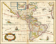
This is a fabulous example of Merian's fine early map of America. The detail is well-executed on this map that stretches from Cape Mendocino to the Tierra del Fuego, and the coloring is bright and very attractive. This map is derived from Jodocus Hondius's earlier 1618 map.
The map includes a marvelous peninsular California with the NW Coast of America stretching almost parallel to the 40th parallel. Over thirty place names appear on the peninsula. The map also includes an unusual east coast of North America, packed full of placenames, including Chesapiooc (Chesapeake), Sanawanook, Hatoraske (Hatteras); Charlefort, Cap de S. Roman, and many more. The Virginian coastline possesses a curious bulge, giving way to a bay in New England. No Great Lakes are shown, except perhaps Ontario and Eerie, nor does Long Island appear.
South America is vastly oversized on the map. A large lake appears just north of the Amazon, in Guiana. Statenlande faintly appears. Other curiosities include the Rio Grande flowing into the Gulf of California, with the seven cities of Cevola appearing at its source. An inset in the top of the map shows the area around Greenland, including the phantom island of Frislandia.
Other attractive details appear throughout the map. Ships and sea monsters appear throughout the southern Pacific and Atlantic. The map includes a simple and decorative cartouche.
This work originally appeared in Merian's Neuwe Archontologia Cosmica, the German translation of Pierre d'Avite's Les Empires du Monde. The map appeared in the 1638, 1646, and 1695 editions of the work and accompanied several other texts as well.
Mathaus Merian (1593-1650) was the father of engraver Matthäus the Younger, and of the painter, engraver, and naturalist Maria Sibylla Merian. He was born in Basel, Switzerland and trained in engraving in Zurich. After a time in Nancy, Paris and Strasbourg, he settled in Frankfurt. While there, he worked for Johann Theodor de Bry, the publisher and son of the travel writer. In 1617, he married Maria Magdalena de Bry, Johann Theodor’s daughter. In 1623, Merian took over the de Bry publishing house upon the death of his father-in-law. Merian’s best known works are detailed town views which, due to their accuracy and artistry, form a valuable record of European urban life in the first half of the sixteenth century
![(Early Mapping of America) Die Entdeckung Amerika's in ihrer Bedeutung für die Geschichte des Weltbildes [with:] Atlas](https://storage.googleapis.com/raremaps/img/small/103238.jpg)
![[English Edition!] Maris Pacifici quod vulgo Mar del Zud](https://storage.googleapis.com/raremaps/img/small/71000.jpg)
