|
||

|

|
|

|
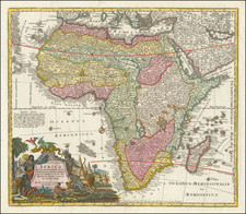
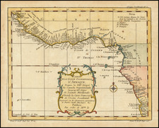
One of the Great Early Maps of West Africa With Significant Manuscript Annotations
Important early map of West Africa showing the coastal region from the Canary Islands to the Bight of Benin and São Tomé and Principe. This a striking, dark impression of the Carol Allard state of the map with numerous annotations in a contemporary hand.
The title cartouche attributes the map to an earlier manuscript sketched by Francisco Revelasco and drafted by Luis Teixeira ca. 1600; Teixeira was an important cartographer during the Iberian Union (1580-1640). The title reads in translation from the original Latin:
Depiction of the expansive and gold-rich kingdom of Guinea in Africa, which stretches from the Atlantic islands popularly called the Cape Verde Islands to the river in Benin on which the great and royal city of Benin lies, and from there to the promontory of Lopez Gonsalvez, drawn by S. Rovelasco and executed in fine line by Ludovicus Texera [Luis Teixeira], chief cosmographer to the Spanish King. A book with an extensive depiction of these regions was published in the same year by P.D.M. [Pieter de Marees]
Based on reports and testimony from travelers like the merchant Menda Motta, the map shows a densely detailed coastline filled with rivers, fishing villages, great cities in Benin and Biafra, as well as what are referred to as castles—fortified positions from which Europeans traded with the interior according to rules largely set by local rulers. One of the first of these was erected by the Portuguese in 1482; it is known as Mina (or Elmina) and is located on the Gold Coast in what is today Ghana.
European castles, controlled variously by the Portuguese, Dutch, English, French, German principalities, Danes, and Swedes, dot the coastline, but that is where their influence, and geographic knowledge, stopped. To hide the lack of knowledge of and power over inland Africa, this map is augmented with two vignettes depicting scenes from the Gulf of Guinea region. They are framed in handsome strapwork. To the right is a procession of nobles entering the city of Benin, while to the left is a scene showing traditional music and dance.
These embellishments are joined by three grand thirty-two-point compass roses (and one sixteen-point half rose) placed in the Atlantic. Two large European ships patrol the waters, as does a stately sea monster. Both the title cartouche (right) and the scale (lower left) are framed in rich strapwork.
Manuscript annotations
This example is particularly spectacular due to its extensive manuscript annotations in a contemporary hand. The largest of these is a block of text in the bottom margin describing the geography of Guinea and the Atlantic islands. Searches of the Latin phrases reveal no clear source, suggesting the text could be original.
Elsewhere, the annotations correct and augment the cartography of the map. In the north, the coastline has been extended to the Strait of Gibraltar, while the Madeira islands are included outside the map’s border. These are accompanied by further descriptions of the Canary Islands which cite contemporary sources.
The Cape Verde islands are also extended and expanded. A note identifies them as the Hesperides, as they were called by Ptolemy, representing the westernmost islands known in the ancient world. Early modern geographers variably identified the Hesperides as the Cape Verde, Canary, and Madeira archipelagos.
On the African continent, mountains have been added in the northwest. As one follows the coast south, the annotator has added additional placenames, as well as alternative names for certain features. He also corrects the placement of certain names, as is the case with Cabo de Verga. The southernmost note, in the right margin, explains that the island of Principe pertains to the Portuguese Crown.
Europeans in Africa to the seventeenth century
The first Europeans to reach sub-Saharan Africa were the Portuguese, who sailed to the Senegal River in 1442. In the three decades prior to this voyage, the Portuguese had established several fortifications along the coast of Morocco. By the 1470s, the Portuguese had established trade relations with West African leaders from Senegal to Ghana. Initially, informal trade models, wherein Europeans settled in local communities in tiny numbers and created trading networks (often led by their African wives), were more common, but these quickly gave way to the factory system by the seventeenth century.
Elmina, established on the Gold Coast in 1482, was the prototype for the trading factory; it was a location for representatives of African kingdoms to meet with the Portuguese and trade, while the Portuguese could store goods and load their ships. This system kept the Europeans relatively contained on the coast. At this time, the Portuguese were especially interested in trading for gold and, increasingly, in enslaved persons.
By the end of the sixteenth century, the Portuguese factories were threatened by Dutch incursions. By 1650, practically all of the Portuguese coastal castles were in Dutch hands. They were also interested in enslaved persons, as well as ivory, animal hides, and textiles. Other European nations followed suit in the later half of the seventeenth century. By this time, the trade in enslaved persons was coming to dominate European commerce with Africa. Eventually, 12.5 million Africans would be transported to the Americas as enslaved labor; many thousands more perished en route to the castles.
Sources for the map
The original manuscript upon which this map is based is credited to Luis Teixeira. Teixeira was one of the most prominent members of a famous family of Portuguese mapmakers. The family was headed by Pero Fernandes (two known charts from ca. 1525 and 1528), father of Luis Teixeira, Marcos Fernandes Teixeira, and (most likely) Domingos Teixeira. Luis has two cartographer sons of his own, João Teixeira Albernaz I and Pedro Teixeira Albernaz.
Luis has thirty-five charts attributed to him. While his place and date of birth are unknown, Luis took an exam to gain permission to make navigational charts in 1564. A permit from 1569 survives, detailing that Luis was responsible to providing the royal fleets with charts and instruments. He is also known for his surveys of Brazil and the Azores and a significant map of Japan. His reputation preceded him; he was admired by Abraham Ortelius and Jodocus Hondius in the Low Countries and Spanish officials (Portugal and Spain were united administratively from 1580 to 1640, which is why he is listed as a cosmographer for Spain in the title of this map).
Little is known about Francisco Revelasco beyond his work on this map. Revelasco and Teixeira created the manuscript version of this map ca. 1600.
States of the map
The map was originally intended to be published in 1602 in Pieter de Marees's Beschryvinge ende Historische wtrhael rtnt Gout koninckrijck tan Gunea, andres de Goutczete de Mina genaemt (Amsterdam, 1602). However, no known copy of this first printed state survives.
The map was engraved by Dutch mapmaker Baptist van Deutecum and released in ca. 1650 (not before ca. 1643) by Hugo Allard. This is a later edition re-issued by Hugo Allard’s son, Carol.
Rarity
OCLC lists four institutional examples of this map (Harvard, Oxford, the British Library, the University of Amsterdam). This is the first time we have encountered the map in thirty years. Finally, this is the only known example to have such rich manuscript annotations.
Carel (Carol) Allard (Allardt) (1648–1709) was an engraver and publisher based in Amsterdam. Part of a prominent family of Dutch mapmakers, publishers, and print sellers, his father was engraver and publisher Hugo Allard (1627–1684), who left his business to Carel upon his death. Carel published anything in demand, including maps, topography, ethnography, newsprints, and restrikes of old plates of artistic prints, many of which likely came from his father’s stock. In 1706, Carel gave his copperplates to his son Abraham Allard, before going bankrupt.