|
||

|

|
|

|
Stock# 68167
Description
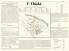
Detailed lithographed map of the Mexican State of Campeche on the western side of the Yucatan Peninsula, published in Mexico in 1861.
The map differentiates between eight (!) different kinds of settlements, including haciendas, rancherias, villas, pueblos, etc.
Interestingly, there "Pueblo destruido" (destroyed towns) are also labeled as such. These destroyed towns may be related to the Yucatan Caste War. Most of these destroyed towns are in the mountainous interior.
Rare. No copies located in OCLC.
The lithographer's imprint reads: "Lithog de Iriarte y Cd. Sta Clara 23. Mexico."
![[ Earliest Obtainable Map of San Diego Bay ] Plan du Port De St. Diego en Californie. . . 1782 [with] Plan Du Port et du Departement de San Blas . . . 1777](https://storage.googleapis.com/raremaps/img/small/90982.jpg)