|
||

|

|
|

|
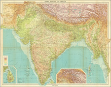
Names the Sea of Korea
A large and very detailed map of East Asia, from India and the Indian Ocean in the west to Japan, Korea, and the Philippines. Place names are extensive on this map, both on land and at sea. French text at the bottom describes the various places on the map. India is attributed as part of the Moghul Empire, China is described as the most powerful nation in Asia, and Sumatra and Java are both described. This map is from Chatelain's monumental 7 volume Atlas Historique.
Annotations add a fascinating dimension to the map. In places such as Tibet, we see cartographic guesses not unlike those found in North America at the time. One river runs from the Himalayas towards an unknown destination in the northeast, and is suggested to perhaps flow into a "black sea." One lake in northernmost India feeds both the Ganges and the "Tibet" rivers.
The East Sea is named the Sea of Korea. The Maritime Continent is well mapped, but to the west lie the "New Philippines." Many islands are named in this apparent ghost archipelago. Chatelain has used several sources, such as those of the Portuguese explorer Texeira, which have led him to map other ghost islands in the Indian Ocean. Despite this (or perhaps, because of it), there are are a surprising number of villages located throughout Indonesia.
Henri Abraham Chatelain first published his Atlas Historique in seven volumes from 1705 to 1720, targeted at an audience eager for all types of information. Particularly focused on geography, Chatelain also touched on cosmography, geography, history, chronology, genealogy, heraldry, and much more. Several volumes would be reprinted until 1739.
Many of the maps Chatelain uses were based on the work of the French cartographer, Guillaume de L'Isle. Other plates were based on the most extensive contemporary travel accounts, including those of Dapper, Chardin, de Bruyn, and Le Hay.
A major focus of the work regards newly colonized lands, which wealthy Europeans were eager to learn more about. His plates and text describe the way of life in these faraway lands, with parts of the work devoted to the Americas, Africa, the Middle East, Mongolia, Indonesia, and much more. Chatelain did not neglect European subjects, describing them in detail as well.
Several plates from the work are particularly renowned, especially Chatelain's fascinating map of the Pacific and the Americas, which shows the Island of California, Korea, Japan, and many other places in intriguing detail alongside extensive text and annotations. In addition, Chatelain's title pages are attractively designed, as are the maps he uses.
There is some debate as to the identity of the compiler of the atlas, described only as Mr. C***. Recent scholarship suggests this might, in fact, be Zacherie Chatelain, not Henri Abraham Chatelain.
Henri Abraham Chatelain (1684-1743) was a Huguenot pastor of Parisian origins. Chatelain proved a successful businessman, creating lucrative networks in London, The Hague, and then Amsterdam. He is most well known for the Atlas Historique, published in seven volumes between 1705 and 1720. This encyclopedic work was devoted to the history and genealogy of the continents, discussing such topics as geography, cosmography, topography, heraldry, and ethnography. Published thanks to a partnership between Henri, his father, Zacharie, and his younger brother, also Zacharie, the text was contributed to by Nicolas Gueudeville, a French geographer. The maps were by Henri, largely after the work of Guillaume Delisle, and they offered the general reader a window into the emerging world of the eighteenth century.