|
||

|

|
|

|
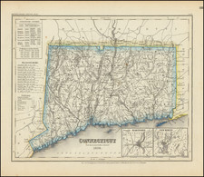
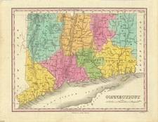
The First Map of Connecticut Published in France
Excellent wide margined example Buchon's finely executed map of Connecticut.
The map includes wonderful contemporary details concerning the topography, indigenous lands, rivers, climate, towns, manufacturing, commerce, education, history, population by county, and other information.
The key notes flags for five remarkable battles.
Jean Alexandre Buchon (1791-1849) was a French scholar and historian. Born as the French Revolution raged, Buchon was dedicated to recovering France’s history in order to help the country heal and grow. He gathered French stories and published them as part of Collection des chroniques nationales franciases ecrites en langue vulgaire, du XIe au XVIe siècle (4 vols, 1824-1829). He also compiled and published an exploration collection and several histories, particularly about medieval France.
For geography, his most important contribution was publication of the French edition of Carey & Lea’s American Atlas in 1825. Each page of the atlas includes highly detailed text about the state or territory depicted, as well as a map of the area. The French edition is generally considered in high regard as compared to other editions, as it has quality paper and superior engraving.
![[ Early Handwritten Annotations ] Connecticut From the best Authorities](https://storage.googleapis.com/raremaps/img/small/100909.jpg)