


|
||

|

|
|

|
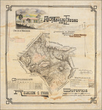
Fine photo-lithographic reproduction of Augustin Diaz's rare plan of Merida, originally published in Paris in 1865 for the Comision Cientifica.
The map notes at the bottom center (obliterated on this copy) that it was reproduced by the Engineer Enrique A. Cervantes in 1945. Cervantes (1898-1953) was and engineer, historian, bibliophile, editor, draftsman, photographer, restorer and art researcher. The present map was almost certainly created in conjunction with his Bosquejos sobre el desarrollo de las ciudad de Mérida, issued in 1945, published shortly after the quadricentennial of the founding of Merida.
Agustín Díaz was a Mexican surveyor, cartographer, and administrator. Trained as a military engineer, Díaz was a skilled surveyor. From 1850-7, he was an integral part of the Mexican surveying team involved in the Comisión Mexicana de Límites con los Estados Unidos following the Mexican-American War. Under the Emperor Maximilian (1864-7), he led a scientific expedition to the Yucatan. He also taught geography at the Colegio Militar, a school he had also attended as a young man. In 1877, Díaz was named head of a cartographic commission that reviewed the state of Mexico’s maps and plans. He found it woefully inadequate and recommended a complete overhaul. His proposal was taken up and he was named head of the newly-created Comisión Geográfico-Exploradora. The CGE was supposed to create a master map of the Republic at a scale of 1:100,000. He served at the CGE until his death in 1893.
![[Acapulco] Haven van Aquapulco in t' Coninkryk van Nova Spagnien in de Zuyd Zee](https://storage.googleapis.com/raremaps/img/small/91246.jpg)
![(Texas - Apache Depredations in Mexico) Discurso Que Pronunció el señor Coronel D. José Joaquin Calvo, Comandante general del Estado de Chihuahua, al entrar en ejercicio del Supremo Poder Ejecutivo del mismo [caption title]](https://storage.googleapis.com/raremaps/img/small/93111.jpg)