|
||

|

|
|

|
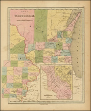
A Foundational Wisconsin Map.
This is an important early map of Wisconsin, published only two years after the territory was incorporated. The map centers on the areas now part of southwestern Wisconsin and eastern Iowa. In this area, the most populated at the time, we see many roads, towns, rivers, and even a proposed railroad from Milwaukee Bay to the Mississippi. An inset shows the greater Wisconsin Territory, extending as far as the Missouri and White Earth Rivers.
The detail on the map extends into Missouri, Michigan, Indiana, and Illinois. Milwaukee, "Madison City," and Chicago are named. "Mennomonieville," "Navarin," and "Astor" all occupy the area now named Green Bay, with Fort Howard overlooking the Fox River. A short railroad is proposed here as well, connecting Winnebago Lake to La Fontaine. The inset shows Carver's Tract.
Many Indian tribes are named in the inset map including the Dakota, Iwoas, Chippeways, and the "New York Indians." This latter was a term for the Native Americans who had been forced westwards during the 1820s after being pushed out of their ancestral lands. This describes tribes such as the Oneida, Stockbridge, Munsee, and Brothertown. An area along the Iowa River is labeled "Neutral Ground," which appears to be acting as a buffer between white settlers and the lands of the Sioux tribes. Later neutral grounds served as buffers between Native American tribes.
Wisconsin's Early Days
The Wisconsin Territory was founded in 1836 from the soon-to-be-former Michigan Territory. The backdrop of the Toledo War (fought between Michigan and Ohio, with one casualty) had delayed the incorporation of the territory, which was supposed to have been founded in 1835. Frequent changes in leadership and delays from Congress led to confusion in the early days of the territory.
By 1837 confusion subsided and Michigan had been granted statehood. This left Wisconsin with a huge tract of land, encompassing all of Minnesota and Iowa, as well as parts of North and South Dakota. The Iowa Territory was then founded in 1838, greatly diminishing the size of the Wisconsin Territory. White settlements were generally restricted to the easternmost part of the territory while Native Americans occupied the western portion of the territory. In the inset, we see Wisconsin in its short-lived 1836-1838 arrangement.
The Carver Tract
The history of the Carver Tract, 10,000 square miles split between what is now Wisconsin and Minnesota, epitomizes many of the shady land dealings which occurred in early territorial America. The exact story is difficult to follow and has partially been lost to history, but the end result is that many spurious claims to this land, without any actual legal backing, were made.
Jonathan Carver himself was a moderately successful officer who served in the French and Indian Wars as part of Burke's (later Rogers') Rangers. After the war, he was interested in exploring the lands newly won by the British Empire. Rogers, his former commander, sponsored his expedition to find a Northwest Passage, which was, of course, unsuccessful. Carver explored the lands which now encompass Wisconsin, Minnesota, and Iowa.
The exact origin of the Carver Tract is uncertain. The Tract was supposedly the result of a grant made in 1767 by the Naudowessie tribe of the Sioux for lands actually owned by their enemies. The first mention of this tract to be recorded comes from Dr. John Coakley Lettsom who had acquired Carver's possessions the year after the latter's death, and claimed that Carver was in possession in such a deed at the time of his death. Carver's widow was unable to locate this grant. Other sources suggest that Carver did indeed have this grant, having forged it himself.
Whether or not this original grant ever even existed, descendants of Carver petitioned Congress for the land, supposedly described as "the whole of a certain tract or territory of land, bounded as follows, viz.: from the Falls of St. Anthony, running on the east bank of the Mississippi, nearly southeast, as far as Lake Pepin, where the Chippewa joins the Mississippi, and from thence eastward, five days travel, accounting twenty English miles per day, and from thence again to the Falls of St. Anthony, on a direct straight line," which would form the sub-triangular shape seen on this map. Congress eventually denied their claim in 1823, after various legal and historical arguments were made showing the many reasons why this claim was illegitimate.
The story of Carver's Tract would not stop there, as Carver's remaining descendants and other conmen would try to sell illegitimate claims to the land for many more years. The Tract would appear on some maps until at least 1842.
State & Rarity
Second state, with the "Philadelphia: Published By | Hinman & Dutton No. 6 North Fifth Street." credit line, which conforms with Hinman & Dutton's credit in the copyright line "...in the year 1837, by Hinman & Dutton", but with the 1838 date rather than 1837 as in the first. This state predates a later one that changes the credit lines considerably to "by | Aug. Mitchell. | Philadelphia | Improved and Published by Henry J. Abel. of Wis. Ter." also dated 1838. Sabin 49 records an 1839 edition.
All states are rare.
![[Black Hawk Purchase] Iowa](https://storage.googleapis.com/raremaps/img/small/69376.jpg)