|
||

|

|
|

|
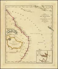
Route Map of the Burke and Wills Expedition Across Australia
Detailed map showcasing the route of the Burke and Wills Expedition, which appeared in the Journal of the Royal Geographical Society to accompany an account of the expedition.
The map shows a north-south strip of land, stretching from the Gulf of Carpentaria to the Darling River area. Outlined in red is Burke and Wills’ route, while Howitts’ travels are in blue.
Numerous creeks line and intersect with the central route, although many are truncated or shown with a tentative dotted line. They are labeled, as are other important observations about the ground consistency and quality. For example, a detour between two “Sandstone Ranges” contains “High red sand ridges” and “Sandy flat & ridges densely cov/d with porcupine grass.”
The Burke and Wills Expedition
As the title block indicates, this map was drawn based on details in Wills’ field book. In the mid-nineteenth century, the interior of Australia remained largely unknown to those of European descent. The Royal Society of Victoria sought to mitigate this lacuna in knowledge by planning a cross-continental expedition that would bisect the country south to north. The explorers were to map their route and to identify possible arable land. They were also to hurry, as the Royal Society of Victoria wanted their men to beat the rival expedition of John McDouall Stuart.
Robert O’Hara Burke, an Irish police officer and soldier, led the expedition’s nineteen men from Melbourne starting on August 20, 1860. Other party members included William Wills, surveyor and astronomer; George Landells, camel master; and Ludwig Becker and Herman Beckler, naturalists. They were accompanied by fifty camels and horses, as well as a large collection of supplies—this was the most expensively outfitted expedition in Australian history.
The men made their slow way north after leaving Melbourne; they were hindered by slow weather, terrible or non-existent roads, and faulty wagons. When they reached the Darling River, Burke split the party, taking Wills and two other men, Charles Gray and John King, with him. In early summer they set out from Cooper Creek, where they had established a depot, as seen on this map. They ordered William Brahé and a few men to guard the supplies left there.
The smaller party continued north during the scorching heat of summer. They reached the Gulf of Carpentaria and turned back on their own path. Along the return, roughly three days journey from Cooper Creek, Gray died. The other three struggled onward, arriving to find Cooper Creek deserted on April 21, 1861. Brahé and the others had just left, hours before, with the food and pack animals.
Burke and his men decided to make for Mt Hopeless, only making it a short portion of the way there. Their farthest point is marked on the map. They then headed back to Cooper Creek where, unbeknownst to them, Brahé had returned and then left again, not having seen their message for him. Back near Cooper Creek, in June 1861, Burke and Wills both perished.
The only member of the small extension party that survived was John King, who was helped by local Aboriginal peoples. He was eventually found by a rescue party led by Alfred Howitt in September 1861. He became the first person to travel across Australia south to north and back.
Brahé and others faced a Royal Commission the following year. However, it was Burke who was criticized; the Commission did not think it wise to have split the party so early in the expedition. Although a failure, the Burke and Wills Expedition still managed to communicate new geographic knowledge, and the rescue parties, led by Howitt, John MicKinlay, and William Landsborough, also made contributions of their own to the geography of inland Australia.
![[ Sydney ] Plan du Comte de Cumberland (Nouvelle-Galles du Sud) d'apres les Cartes Angloises](https://storage.googleapis.com/raremaps/img/small/77739.jpg)