|
||

|

|
|

|
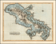
The Earliest Detailed Map of Aruba
This is the first detailed map of Aruba. Made in the year 1825, it was based on information from Captain W. A. von Spengler's 1820 survey and enriched with several new provisions particularly focused on the discovery of gold. The map shows topography, landforms, buildings, gold deposits, and more, as well as including a list of sixty-one features throughout the island.
This map is the first to name Oranjestad, which was then a small settlement with a port protected by some barrier islands. Fort Zoutman, now home to the island's Historical Museum, stands at the edge of this hamlet. Two churches are shown, including one likely to be the Saint Anna Church, though the Alto Vista Chapel, the oldest church on the island, is omitted. A few hills are scattered around the island, with a series of small ridges in the southernmost tip. For the most part, the island is bare of vegetation, reflective of its unusually arid climate for a Caribbean island.
The key names many different features, both manmade and natural, which can still be located throughout the island. The map is further decorated by an attractive scale bar and compass rose. This map preserves an image of Aruba prior to the dense construction that now occupies the island.
Aruba was a Dutch colony first occupied in 1636 after the Thirty Years' War. No recorded maps of its coastline were made until 1773, when a large map on seventeen sheets appeared, made by the Lieutenant Engelbertus Horst. Another map would be produced in 1779, this one showing five hills on the island, but lacking any substantial details. No buildings are shown on either map. The island started to be properly colonized in 1796 when Oranjestad was founded. Fort Zoutman was completed two years later, though the island was occupied intermittently between 1799 and 1816 by the British Empire during the Napoleonic Wars.
After the Netherlands was regiven control of their overseas possessions in the 1814 Anglo-Dutch Treaty, maps of Curacao and Bonaire (B and C in the ABC islands) were quickly made. Von Spengler volunteered to map Aruba, which he did in 1820. A manuscript map of the island was produced and sent to The Hague. We are unable to confirm whether this manuscript still exists.
The Aruban Gold Rush
Gold was first discovered in 1824 in Aruba. A twelve-year-old shepherd stumbled upon some ore, igniting a gold fever. Captain R.F. van Raders was sent to the island to investigate and voyaged to the island three times over the course of 1824 and 1825. He had with him von Spengler's map, to which he added annotations regarding the discovery of gold and silver. Raders added landmarks 42 to 61, of which at least nine indicated localities where "goud" and "zilver" had been found.
This first Aruban gold rush would last until 1830 with only a relatively local impact. More veins would be discovered in 1854, and industrial mining would continue until 1916. This map provides one of the earliest records of this gold rush, which preceded the Californian one by nearly a quarter-century.
In conclusion, this is the first detailed map of Aruba, and the first map located to mention Oranjestad and Fort Zoutman. The National Library of Aruba only has two earlier maps of the island, neither showing inland detail. The map is attractive and simply laid out while conveying a great deal of information.
Rarity
OCLC records only three examples: Duchess Anna Amalia Library in Weimar, Germany; University of Leiden; and the University of Amsterdam Library. In addition to this, we note an example illustrated by the Aruba National Library.
Another edition was published in 1827, which can be differentiated with the line in the lower-right corner: "Dl. Veelwaard en Zoon, Sculp. 1827." The 1827 edition is more common on the market; this is the first time we have seen the 1825 for sale.
![The Coast of Newfoundland From Plancentia to Cape Bonavista [and] A Draught of the River Plata in South America [and] Havana, Harbour [and] the Bay of Honda](https://storage.googleapis.com/raremaps/img/small/38599.jpg)
![The Island of Cuba [with] Hayti or Santo Domingo and Porto Rico [with] The Leeward or North Caribee Islands](https://storage.googleapis.com/raremaps/img/small/78673.jpg)