


|
||

|

|
|

|
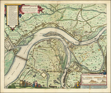
A Rare Example of a Forgotten Battle of the Thirty Years' War
An antique map showing troop movements near Lautereck in the Palatinate of the Rhine. Text identifies the troops as Spanish and Swedish, and the location and period indicate that this is likely part of the first Swedish Intervention of the Thirty Years' War. This would date the battle to 1631 or 1632. Despite the records of dozens of other battles in this conflict, none appear to be in the region shown by this map. Even a detailed history of the town and environs of Lautereck fails to identify this battle. The level of detail shown by Merian suggests that this was a real battle, leading one to wonder why it was forgotten by history.
This map is attractively designed, showing an agricultural part of the Rhineland. Streams and rivers flow northwards from forested hills past attractive German villages. Woodlands and pastures are scattered throughout the map. In addition, we see military action, with troops firing and the village of Razenhau in flames.
The area shown corresponds to that around the Glan and Alsenz rivers twenty-five miles southwest of Mainz. Lauterecken still exists as a small administrative center for the immediate area, and a town named Rockenhausen is likely the modern name for Razenhau. Some of the cartography is accurate, particularly in the succession of towns along the Glan ("Lauter flu"), while to the east the cartography may be slightly more dubious. For example, the modern Stalberg, most likely stand-in for Stalberck, is on a hill without a river flowing through it, while the mapped city lies in a river valley.
The troop movements are described extensively in German and we see a series of seven different stages in the battle. The battle appears to start in the southeastern region of the map, with the Spanish army holding the high ground. Flanking attempts by the Swedish army seem to fail, and they are pushed back across the river. Razenhau is burned, and the armies retreat via Lautereck.
The Swedish Intervention
The Thirty Years' War was one of the most destructive wars in human history and lasted from 1618 to 1648. Started as a feud between Protestant and Catholic states of the Holy Roman Empire, the war became a continent-wide battle for power and dominance.
The Swedish Intervention commenced in 1630 with the troops landing in Pomerania. Gustavus Adolphus, the warrior-king of Sweden, had been sidelined in this conflict due to the separate Swedish-Polish conflict. Peace with Poland and financial backing from Cardinal Richelieu, who was backing the Protestant cause to increase French power, enabled him to enter the war.
After securing Pomerania by the end of 1630, Adolphus and Swedish troops set westwards towards Schweligs-Holstein. Eventually, after several setbacks, the King took Frankfurt and wintered there. This would be the furthest west he would make it; there are no indications that any Swedish troops went past Mainz. After exiting Frankfurt, Adolphus undertook a lengthy yearlong march to his death in Lutzen. After this, the Swedish armies continued to fight while new combatants entered the fight and new phases of the war started. The war would drag on for another sixteen years after the King's death.
The Swedish phase of the conflict left many legacies, including leading to the reform of the structure of European armies, redrawing the lines of religious allegiance, and leaving three-year-old Princess Christina as Queen of Sweden.
The Battle of Latuereck
The Swedish Intervention was the only plausible time that Swedish and Spanish forces would have met in the Rhineland, but, as stated, records do not show Adolphus's forces going west of Mainz. Fighting did occur in this region during the French Intervention (though slightly to the south, to be precise), but by this time Swedish forces were in Austria and eastern Germany.
Explanations for this ghost battle are difficult to concoct. If it did occur, which seems likely given Merian's otherwise accurate histories, traditional accounts of the Thirty Years' War may have to be rewritten. It is also possible that Merian may have confused some facts, and this could perhaps be from the French phase of the war with mistaken participants.
The suggestive history that this engraving purports only adds interest to this attractive and detailed map.
Mathaus Merian (1593-1650) was the father of engraver Matthäus the Younger, and of the painter, engraver, and naturalist Maria Sibylla Merian. He was born in Basel, Switzerland and trained in engraving in Zurich. After a time in Nancy, Paris and Strasbourg, he settled in Frankfurt. While there, he worked for Johann Theodor de Bry, the publisher and son of the travel writer. In 1617, he married Maria Magdalena de Bry, Johann Theodor’s daughter. In 1623, Merian took over the de Bry publishing house upon the death of his father-in-law. Merian’s best known works are detailed town views which, due to their accuracy and artistry, form a valuable record of European urban life in the first half of the sixteenth century
![[Kehl, Riverfront Fortifications in 1726]](https://storage.googleapis.com/raremaps/img/small/59629.jpg)