


|
||

|

|
|

|
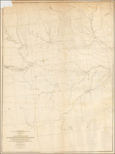
A rare antique map of the midwest and plains, extending into "Kanzas", Nebraska and Indian Territory, from Rogers & Johnston's Atlas of the United States. This atlas was an unusual collaboration between an American, an Englishman, and a Scot. This is one of the rarest American atlases of the 19th Century.
The map names counties, towns, rivers, Indian tribes and much more. It portrays a collection of states with close ties that were about to be torn apart by the Civil War. Adjacent Kansas [Kanzas] is shown as having gained statehood after the "bleeding Kansas" events of 1854, events in which Missouri settlers played a huge role. This would foreshadow the events taking place in their own state during the war, a state deeply divided between pro-Union and pro-slavery sympathizers. Battles raged throughout all these states, as part of the Trans-Mississippi Theater.
The map is a fragment of Rogers & Johnston's excellent and equally rare wall map. The evolution of the Rogers & Johnston work extends to 1873, when a modified example of the wall map was issued in atlas form, first as the People's Pictorial Atlas by J. David Williams and later as the Jones Historical Atlas, two of the rarer and more interesting late 19th Century American works. An important rarity for map collectors of this region.