|
||

|

|
|

|
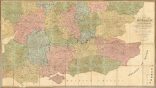
Antique map of the Surrey and adjoining Home Counties. In the 18th century layout of the county, the northern border is marked by the River Thames, and Surrey includes parts of London, though Westminster and the Isle of Dogs form part of Middlesex. Guildford, Chelsea, Battersea, and many other settlements are shown. Small parts of adjoining counties, including Kent, Sussex, Hampshire, Barkshire, and Middlesex are shown. Roads, rivers, and hills are portrayed. Part of what Zatta might have considered a typical Surrey scene, with a lone pine tree, is shown next to the title.
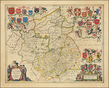
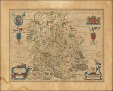
Antonio Zatta (fl. 1757-1797) was a prominent Italian editor, cartographer, and publisher. Little is known about his life beyond his many surviving published works. It is possible that he was born as early as 1722 and lived as late as 1804. He lived in Venice and his work flourished between 1757 and 1797. He is best known for his atlas, Atlante Novissimo (1779-1785), and for his prolific output of prints and books that were both precisely made and aesthetically pleasing. Zatta clearly had a large network from which to draw information; this is how he was able to publish the first glimpse of the islands visited by Captain Cook in the Atlante Novissimo. Zatta also published books of plays and architecture.
![Regionis, quae est circa Londinum specialis repraesentatio geographica, ex autographo majori Londinensi . . . 1741 [Includes Bird's-eye View of London and Westminster]](https://storage.googleapis.com/raremaps/img/small/95041.jpg)
![[Western England and Wales] Le provincie che sono all'ovest dell'Inghilterra e quelle del principato di Galles](https://storage.googleapis.com/raremaps/img/small/82448.jpg)