|
||

|

|
|

|
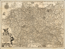
Decorative and highly detailed map of Upper Saxony. Covers the region North of the Egger and Mein River, East of the Werra River, South of the Sprehe and West of the Bober. Includes Marquiat De Lusace, Marquisat De Misnie, Duche et Esclectorat De Saxe, Principaut D'Anhault, Landgraviat De Thuringa, Duche De Saxe Altenburg and Duche De Weimar, among others. Centered on Leyptzig, Meissen, Dresden and Wittenberg. Map is dissected by the Elbe and Sala Rivers. Two decorative cartouches.
The Ottens brothers, Reiner and Joshua, operated a successful printing partnership in the mid-eighteenth century (fl. 1726-1765). They began the venture in 1726, publishing maps and other prints as “R & I Ottens.” They specialized in the reprinting of others’ work, especially Guillaume De L’Isle. In 1750, Reiner died; his soon, also Reiner, took his place, but the firm began listing their works as “Joshua & Reiner Ottens.” The firm lasted until Joshua’s death in 1765. Joshua’s widow, Johanna de Lindt, sold their remaining stock of plates in 1784.
Alexis-Hubert Jaillot (ca. 1632-1712) was one of the most important French cartographers of the seventeenth century. Jaillot traveled to Paris with his brother, Simon, in 1657, hoping to take advantage of Louis XIV's call to the artists and scientists of France to settle and work in Paris. Originally a sculptor, he married the daughter of Nicholas Berey, Jeanne Berey, in 1664, and went into partnership with Nicholas Sanson's sons. Beginning in 1669, he re-engraved and often enlarged many of Sanson's maps, filling in the gap left by the destruction of the Blaeu's printing establishment in 1672.
![[ Electors of the Holy Roman Empire ] Ordines Sacri Romani Imp: Ab Ottone III Instituti](https://storage.googleapis.com/raremaps/img/small/99053.jpg)