


|
||

|

|
|

|
Lewis & Clark's Map on a Mammoth Scale -- Advertising for Subscribers in June 1807.
One of the earliest printed announcements for the publication of Lewis & Clark's map and the Official Account of the Lewis & Clark expedition, which appeared in The Democratic Press on August 10, 1807 (page 4).
The advertisement for the map is signed June 19, M[eriwether] Lewis, notes that the map would be for sale for $10.00, with the two volume Official Account also selling for $10.00.
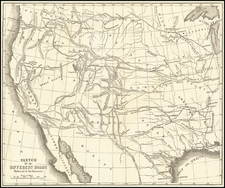
Among other things, the map is noteworthy for its size, as it suggests the original intention was to create what would appear to be a 6 sheet map. The final printed map which would not be published until 1814. The map is entitled A map of Lewis and Clark's track, across the western portion of North America from the Mississippi to the Pacific Ocean : by order of the executive of the United States in 1804, 5 & 6, is only 28 x 12 inches. The map advertised here was 5 feet 8 inches by 3 feet ten inches (68 x 46 inches or about 182 cm x 120 cm) which is slightly larger than William Clark's manuscript map of 1810, currently in the Yale Beinecke Collection: https://brbl-dl.library.yale.edu/vufind/Record/3436565?image_id=1053073
It is known that William Clark continued to update the map with new information long after the completion of the expedition. The advertisement notes that the map:
Embrace[es] all their late discoveries, and that part of the continent, heretofore the least known. This map will be compiled from the best maps now extant, as well published in manuscript, from the collective information of the best informed travellers through the various portions of that region, and corrected by a series of several hundred celestial observations, made by captain Lewis during his late tour.
The Lewis & Clark Expedition & Map
The expedition, commissioned by Thomas Jefferson and funded by Congress in early 1803, was the first exploration officially sponsored by the Federal government. The acquisition of Louisiana Territory, finalized in December 1803, increased the importance and urgency of the expedition, which set out from St. Louis in May 1804 and covered 8000 miles in the next 2 years, crossing the Rocky Mountains and reaching the mouth of the Columbia River before returning by the same route.
The extremely accurate and detailed map, based on Clark's manuscript, was termed by Wheat the "master map of the American West" (quoted in Cohen). The remarkable cartographic achievement, perhaps even more than the written account of the journey, served to impel and motivate the nation's inexorable westward expansion.
Publication of Lewis's and Clark's account of the epic expedition was delayed by the appointments of both leaders to official positions in the new Louisiana Territory (Lewis as territorial Governor and Clark as Superintendent of Indian Affairs), and later by Lewis's murder or suicide in 1809. This "most important of all overland narratives" (Grolier) was finally brought to press in 1814, with the map issued separately.
The Newspaper
Other cartographic offerings include:
- Moore & Jones Road Atlas of the United States
- Guthrie's Geography (at Mathew Carey's Store)
- Pinkerton's Modern Geography
- Morse's Universal American Geography
- Scott's New and Universal Gazetteer
- Scott's Geographical Dictionary of the United States of North America
- Brook's General Gazetteer Improved
- Walker's Elements of Geography
- Vyse's Comprehensive System of Modern Geography
- Scott's Geographical Description of Pennsylvania
The Democratic Press
The Democratic Press was started on March 27, 1807 by John Binns of Philadelphia. It became Pennsylvania's leading newspaper, until its demise in 1829 during the Jackson administration.
Its announcement of the death of Meriwether Lewis in November 1809 was among the earliest notices of his death.
Rarity
This would appear to be at least the second printing of the advertisement. Thwaites notes a printing which is dated June 3rd, 1807.
![Distribution of Vegatables and Snow Line [with] Comparative Lengths of Rivers](https://storage.googleapis.com/raremaps/img/small/97865.jpg)
![[Eurpean and American Air Routes] TWA Trans World Airline U.S.A. • Europe • Africa • Asia Air Routes](https://storage.googleapis.com/raremaps/img/small/89027.jpg)
![Sphere De Ptolemee [with] Rose De Boussole…](https://storage.googleapis.com/raremaps/img/small/63929.jpg)
![[ Confederate States of America Naval Flag! ] Pavillons des Principales Puissances](https://storage.googleapis.com/raremaps/img/small/88973.jpg)