![Charte von Nord-America Prag 1818 [Rare Alaska Inset Map] By Franz Pluth](https://storage.googleapis.com/raremaps/img/small/72184.jpg)


|
||

|

|
|

|
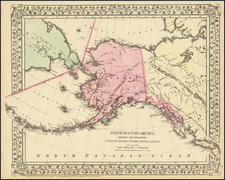
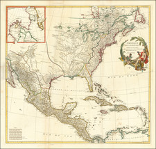
Rare and unusual map of North America, published in Neueste Lander und Boltersunde, in Prague. The map provides a fascinating depiction of the Transmississippi West, with unusual mountain ranges and a wishful but elusive search for a simple watercourse from the Missouri to the Pacific, with hints of short portages in across relatively minor Pacific Coastal Ranges. One of the map's most interesting features re the extraordinarily southern course of the Missouri and its tributaries to the South, which easily traverse the course of the Plains, past the non-existent Rocky Mountains, and into Utah, New Mexico, Arizona, Nevada and the eastern Part of California, with the Platte, Little Missouri, Panis and Gallatin reaching the coastal range before ending without quite reaching the Pacific.The map is rich with Indian detail in both the Transmississippi West and the Missouri and Mississippi Valleys. The discoveries of the Hudson Bay Company and the trading houses established in the late 18th and early 19th Centuries are much better documented, with dates of exploration, dozens of trading houses located and other notes. The map includes nice post-Vancouver, post-La Perouse information along the NW and California Coastlines, with a detailed inset map of Alaska. Mississippi Territory has not yet been divided and Ohio and Michigan do not appear. Not in Wheat, who would have enjoyed the anomalous qualities of this map. 4 inch fold split and some offsetting, but still a good example of this rare map.