This item has been sold, but you can enter your email address to be notified if another example becomes available.


|
||

|

|
|

|
Stock# 66895
Description
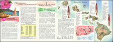
Nice example of one of the earliest maps of Oahu published by the United States Government.
The map notes that the Hawaiian crown lands are colored in yellow and the Government lands are colored in Green. Boundaries are as established in the Great Division of 1848. The Crown lands were those reserved by Kamehameha III for his private use and thereafter transferred to family, etc.
Includes topographical features, place names, early roads and other details.
Made under the direction of W.D. Alexander, the founder of the Hawaiian Government Survey, and drawn by C. J. Lyons.
Condition Description
Folding map. Some minor rust spots and toning along folds. Better than usual.