The item illustrated and described below is sold, but we
have another example in stock. To view the example which
is currently being offered for sale, click the
"View Details" button below.
![Map of the Great Salt Lake and Adjacent Country in the Territory of Utah [with] The Great Salt Lake (Mormon) City And Surrounding Country By Edward Weller](https://storage.googleapis.com/raremaps/img/small/95021.jpg)


|
||

|

|
|

|
Stock# 66792
Description
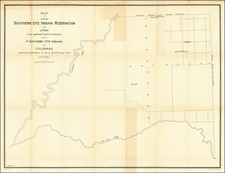
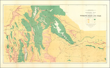
The Earliest Atlas Map To Focus on The Salt Lake City Region and Mormon Settlements
Two excellent early regional maps of the Salt Lake area.
The upper map extends a bit west of the Lake to the Uintas and South to Lake Utah, as well as considerably east of the lake and the Wasatch. Includes a town plan for Salt Lake, roads, other towns, rivers, etc.
The lower map focuses on the area around Salt Lake City and includes a nice town grid, plus some other areas south of downtown which are recently laid out, including Welsh settlement and Big Field. The City Mill is shown, as are another Mill, a cave and other fine details.
A scarce map, one of the best early maps of the area which is reasonably obtainable by collectors.
![[Moab, Utah / Oil] Oil Field Moab Area Utah / Embar Oil Company](https://storage.googleapis.com/raremaps/img/small/71812.jpg)