|
||

|

|
|

|
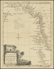
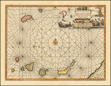
Rare separately published sea chart of the Chagos Archipelago, published in London by Sayer.
Chagos Archipelago
Portuguese explorers were the first Europeans to discover the archipelago. Portuguese navigator Pedro de Mascarenhas (1470 – 23 June 1555) is credited with having discovered the islands during his voyage of 1512–13, but the first maps to show the region date to 1532.
The Portuguese named the area Bassas de Chagas, but the islands were never made part of the Portuguese Empire. The earliest and most interesting description of the Chagos, before coconut trees grew widely on the islands, was written by Manoel Rangel, a castaway from the Portuguese ship Conceição which ran aground on the Peros Banhos reefs in 1556.
The French were the first to lay a claim on the Chagos after they settled Réunion Island (in 1665) and Isle de France (now Mauritius, in 1715). The French began issuing permits for companies to establish coconut oil plantations on the Chagos in the 1770s. On April 27, 1786 the Chagos Islands and Diego Garcia were claimed for Great Britain, but not formally ceded to Britain until after Napoleon's defeat, in 1814.
Diego Garcia and the rest of the Chagos islands were uninhabited until the late 18th century. In 1778, the French Governor of Mauritius granted Monsieur Dupuit de la Faye the island of Diego Garcia, and evidence exists of temporary French visits to collect coconuts and fish. Several Frenchmen living in "a dozen huts" abandoned Diego Garcia when the British East India Company attempted to establish a settlement there in April 1786.
The supplies of the 275 settlers were overwhelmed by 250 survivors of the wreck of the British East Indian Ship Atlas in May, and the colony failed in October. Following the departure of the British, the French colony of Mauritius began marooning lepers on Diego Garcia, and in 1793, the French established a coconut plantation using slave labor, which also exported cordage made from coconut fiber, and sea cucumbers, known as a delicacy in the Orient.
Commander Robert Moresby made the first scientific survey of the Chagos on behalf of the British Admiralty in 1838.
Robert Sayer (ca. 1724-1794) was a prominent London map publisher. Robert’s father was a lawyer, but his older brother married Mary Overton, the widow of prominent mapmaker Philip Overton and the proprietor of his shop after his death. Mary continued the business for roughly a year after her marriage and then, in early 1748, it passed to Robert. Robert became a freeman of the Stationers’ Company later that year; his first advertisement as an independent publisher was released in December.
Sayer benefited from Overton’s considerable stock, which included the plates of John Senex. In the 1750s, Sayer specialized in design books and topographical prints, as well as comic mezzotints. In 1753, he, along with John Roque, published a new edition of Thomas Read’s Small British Atlas, the first of several county atlases that Sayer would publish.
Sayer’s business continued to grow. In 1760 he moved further down Fleet Street to larger premises at 53 Fleet Street. In 1766, he acquired Thomas Jefferys’ stock when the latter went bankrupt. In 1774, he entered into a partnership with John Bennett, his former apprentice. The pair specialized in American atlases, based on the work of Jefferys. They also began publishing navigational charts in the 1780s and quickly became the largest supplier of British charts in the trade.
Bennett’s mental health declined, and the partnership ended in 1784. As Sayer aged, he relied on his employees Robert Laurie and James Whittle, who eventually succeeded him. He spent more and more time at his house in Richmond. In 1794, he died in Bath.