|
||

|

|
|

|
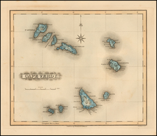
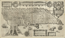
The First Commercially Published Map of the Amirantes and Seychelles
First state of this rare early sea chart of the Seychelles, published by Robert Sayer in London.
The chart covers the Mahe and Amirantes islands, also known as the Three Brothers and the Seven Brothers, along with their shoals, at at time when the region was a French Colony. The map comes in the midst of the period of French control of the islands, which had become an important point of commerce in the Western Indian Ocean.
The chart includes extensive soundings, notes on the sea floor, commentary on reefs, rhumb lines, shoals, place names and a wealth of other practical information for the mariner.
The map is based upon a rare separately published chart by Jacques-Raymond de Giron-Grenier, published in Paris and engraved by Lattre, which apparently survives in a single example in the Bibliotheque National de Paris. Grenier's map was the first scientific mapping of the Seychelles and Amirantes Islands. French naval officer Jacques Raymond de Giron-Grenier (1736 - 1803) conducted an important 1769 mission to assess the islands for permanent settlement and to monitor the local ocean currents in order to find a faster sailing route between Southern Africa and India.
French Control of the Seychelles
In 1768, Nicolas Dufresne arranged a commercial venture, sending ships to collect timber and tortoises from the Seychelles. During this expedition, French sovereignty was extended to cover all the islands of the granitic group on Christmas Day.
In 1769, the navigators Rochon and Grenier proved that a faster route to India could safely be taken via the Seychelles, making the islands an important stopover for European trade with Asia. In the same time period the French brought seedlings of nutmeg and clove, and 10,000 nutmeg seeds in an effort to establish a cash crop on the islands. In the next years, French colonists then brought large amounts of creole slaves from Mauritius to the Seychelles, which became the ancestors of the present population.
Following the French Revolution of 1790, the colonists formed an Assembly in an attempt to govern the islands autonomously. Jean Baptiste Quéau de Quincy became the leader of the colony in 1794, the same year this map was created. When armed British warships arrived, later in 1794, he negotiated favorable terms of capitulation and the Seychelles became a prosperous neutral colony. When nearby Mauritius finally surrendered in 1810, at the end of the Napoleonic Wars, the British took full control of the entire region.
Rarity
The map is extremely rare on the market. This is the first example we have ever seen.
Robert Sayer (ca. 1724-1794) was a prominent London map publisher. Robert’s father was a lawyer, but his older brother married Mary Overton, the widow of prominent mapmaker Philip Overton and the proprietor of his shop after his death. Mary continued the business for roughly a year after her marriage and then, in early 1748, it passed to Robert. Robert became a freeman of the Stationers’ Company later that year; his first advertisement as an independent publisher was released in December.
Sayer benefited from Overton’s considerable stock, which included the plates of John Senex. In the 1750s, Sayer specialized in design books and topographical prints, as well as comic mezzotints. In 1753, he, along with John Roque, published a new edition of Thomas Read’s Small British Atlas, the first of several county atlases that Sayer would publish.
Sayer’s business continued to grow. In 1760 he moved further down Fleet Street to larger premises at 53 Fleet Street. In 1766, he acquired Thomas Jefferys’ stock when the latter went bankrupt. In 1774, he entered into a partnership with John Bennett, his former apprentice. The pair specialized in American atlases, based on the work of Jefferys. They also began publishing navigational charts in the 1780s and quickly became the largest supplier of British charts in the trade.
Bennett’s mental health declined, and the partnership ended in 1784. As Sayer aged, he relied on his employees Robert Laurie and James Whittle, who eventually succeeded him. He spent more and more time at his house in Richmond. In 1794, he died in Bath.
![[Ascension Island] The True Description of the Island of Ascention lyeing under 8 degrees on ye South syde of ye Equinoctiall lyne.](https://storage.googleapis.com/raremaps/img/small/78964.jpg)