|
||

|

|
|

|
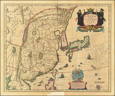
Canton, Macao & the Area Around Hong Kong – The VOC Secret Atlas
Striking, detailed chart of the area stretching from Canton and Macao to Cochinchina, which today is Vietnam.
This chart was made for and used by the Dutch East India Company (VOC), who dominated European trade with Southeast and East Asia in the seventeenth century. It appeared in volume VI (1753) of Johannes II Van Keulen's Zee-Fakkel, the so called "secret atlas" of the VOC.
The chart traces the coastline around the island of Hainan, here Aynam. There is much information here vital for the navigator on dangerous or unknown shores. There are sounding depths, sailing directions, navigational obstructions, sandbars, and rhumb lines.
This area was especially important for the Dutch, and all Europeans, as Macao and Canton were some of the only access points for Europeans to Chinese trade. These waters were also patrolled by pirates and other hostile Europeans rivals, making charts of the area particularly valuable.
The Secret Atlas
The Portuguese were the first Europeans to gain power in the East Indies, trading for spices in the Moluccas and controlling the spice market in Europe. The Dutch wanted in on the lucrative trade. In 1602, rich merchants formed the Dutch East India Company after sending several reconnaissance voyages to establish trade.
Managing the geographic information surrounding the East India route became a priority for the new company. They appointed official hydrographers who were supposed to update and issues charts to captains. They also established hydrographic offices in Amsterdam and Batavia.
During their first 150 years, only tightly-monitored manuscript charts were used in order to minimize the risk of spreading the knowledge to competitors. From the mid-eighteenth century onwards, a printed atlas was used. In addition, the number of charts in the printed pilot guide was often limited because ships that did not sail to India/Ceylon or China and Japan were given restricted versions of the atlas that did not contain the charts of these areas.
The charts in this atlas were produced by Johannes (II) Van Keulen, official hydrographer to the VOC since 1726, and it eventually became part VI of his successful Zee-Fakkel (Sea-Torch). The atlas is known as the so-called secret atlas because its charts were not initially sold and were only used by VOC ships.
The charts in that volume of the atlas were and are rare.
The Van Keulens were a family of chartmakers and publishers. The firm, In de Gekroonde Lootsman (In the Crowned Pilot), was founded in 1678 by Johannes van Keulen (1654-1715). Van Keulen originally registered his business as a vendor of books and instruments (specifically cross-staffs). In 1680, however, he gained a privilege from the States of Holland and West Friesland for the publication of pilot guides and sea atlases.
In that year, van Keulen released his Zee-Atlas (Sea Atlas), which secured him a name in the competitive maritime publishing market. In 1681, he published the first volume of Nieuwe Lichtende Zee-Fakkel (New Shining Sea Torch). This would be the first of an eventual five volumes originally published between 1680 and 1684. A sixth volume was added in 1753. The Zee-Fakel won van Keulen lasting fame. The atlas had charts compiled by Claes Jansz Vooght and artwork from Jan Luyken. It proved immensely popular and was reprinted until 1783. There were translations in French, English, Spanish, and Italian.
The late-seventeenth century was an auspicious time to enter the maritime chart business. Previous industry leaders had either closed shop, died, or retired, leaving space for a new competitor. Van Keulen proceeded to buy up the stock and privileges of several maritime publishing firms; the most notable was the stock of Hendrik Doncker, acquired in 1693.
Johannes’ son, Gerard (1678-1726) took over the business upon his father’s death. Gerard was a skilled engraver and mathematician. His talents were noticed, as in 1706 he was named as Hydrographer to the Dutch East India Company (VOC).
In turn, Gerard’s son Johannes II (1704-1770) came to run the shop. He was also tied to the VOC, and his role as their chartmaker allowed his charts to be considered as quasi-official government documents. It is with access to formerly clandestine VOC geographic knowledge that Johannes the Younger was able to add a sixth volume to the Zee-Fakkel, which covered the East Indies. Johannes also continued to sell instruments, including the recently-invented Hadley’s Quadrant from 1744.
When Johannes II died in 1770, his widow ran the business in his stead, aided by her two sons, Cornelis Buys (1736-1778) and Gerard Hulst (1733-1801). Now a century old, the family business had extended to include an anchor factory. After Cornelis died in 1778, Gerard took on the management of the firm alone. He oversaw the introduction of sextants to their inventory and published the Dutch Nautical Almanac beginning in 1788. Annual editions appeared until 1885. Gerard also served as an original member of the Dutch Commission for Longitude at Sea from 1787.
Gerard’s widow ran the business for nine years after his death, when their son, Johannes Hulst, started to lead the firm in 1810. After his death in 1844, the firm passed out of family hands and into the control of Jacob Swert, a skilled cartographer who had worked for the business for two decades. He passed the work to his son, another Jacob, in 1866. By the mid-nineteenth century, the conversion from sail to steam had diminished the size of the market for charts. Fewer sailors needed fewer maps, charts, and instruments. In 1885, after 207 years in business, In de Gekroonde Lootsman closed its doors and auctioned its stock.
![(China) КАРТА КИТАЙСКAГО ГОСУДАРСТВА. [Map of the Chinese State.]](https://storage.googleapis.com/raremaps/img/small/56505.jpg)