This item has been sold, but you can enter your email address to be notified if another example becomes available.


|
||

|

|
|

|
Stock# 66544
Description
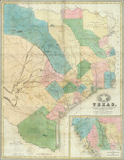
Antique Texas General Land Office map of Jefferson County, Texas. The map was prepared in 1879 by W.C. Walsh, Commissioner of the Genl. Land Office.
This example of the map has manuscript annotations related to land sales and the oil industry. Three red pencil circles have been drawn on the map, one at the Big Hill salt dome oilfield, one at the High Island oilfield, and the other at the Spindletop oilfield.
This example was owned by Galveston-based surveyor R.W. Luttrell. Luttrell was active through the initial Texas oil boom.
![[ Texas - Dallas to El Paso ] Flight Chart- Dallas Fort Worth to El Paso, U.S.A.](https://storage.googleapis.com/raremaps/img/small/98371.jpg)

![[ Texas-Mexico Border Treaty ] Que á efecto de facilitar el cumplimienio [i.e. cumplimiento] del art. 3. del Tratado de limites entre estos Estados y los Unidos del Norte América ... Habiéndose concluido y firmado en la Ciudad de México á los 12 dias del mes de Enero de 1828, un tratado entre los Estados-Unidos Mexicanos y los Estados-Unidos de América [A Treaty having been concluded and signed in the City of Mexico on the 12 day of January 1828 between the United States of America and the Mexican United States for the purpose of establishing the true dividing line and boundary between the two nations]](https://storage.googleapis.com/raremaps/img/small/100806.jpg)