


|
||

|

|
|

|
Excellent 19th-Century Facsimile of one of the Great Early Italian Woodblock Maps.
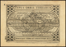
Impressive reproduction of Giovanni Andrea Vavassore's circa 1540 woodblock map of the world, issued by antiquarian map dealer Frederik Muller & Cy. in 1894.
The map was part of a limited series of reproductions that Muller made of the most important maps that he had access to at the time. The maps from the series are extremely are today.
Shirley (75) writes of Vavassore's map:
ONLY FOUR or five copies are known of this woodcut map. It was (according to the imprint on most of the copies) the work of Giovanni Vavassore, the Venetian woodcutter and publisher who was active for over fifty years. His world map could have been prepared as early as the 1520s, based on Bernard Sylvanus' world map printed in the same city a decade earlier, and a date of c.1522 is indicated by some authorities. However a later date of c.1540 seems more probable in the light of Vavassore's general activity. Muller in the reference below suggests 1530-1550.
Compared with Sylvanus, no new geographical features have been added and the whole map concentrates on the Old World with only the easternmost parts of the Americas included. Vavassore's projection, a laterally-extended heart-shaped one, distorts the proximity of the Americas so that South America is just off Africa, the West Indies close to Spain and Terra Laboro (Newfoundland or Labrador) almost touching Ireland . As with Sylvanus' map, prominence is given to mountain ranges and rivers: there are also twelve windheads.
The British Museum's copy of this map is thought to be an earlier state as it does not have the attribution to Vavassore in the lower left-hand comer: alternatively it could be a later pull by another publisher. A reissue in about 1545 is suggested by Bagrow.
Note Vavassore's re-issue in 1558 of Caspar Vopell's great wall map of 1545, described under Entry 102.
The Edward Luther Stevenson Collection
Edward Luther Stevenson was among the most important scholars of early cartography active at the end of the 19th century and the first half of the 20th. He was responsible for numerous cartobibliographic books, including the first translation of Ptolemy to English, as well as a series of impressive facsimile maps produced while he was at the Hispanic Society of New York. Dr. Stevenson viewed facsimiles as integral to the study of early cartography, and he committed himself to building an unparalleled collection of photographs of early maps and globes. Much of his collection was donated to Yale University after his death (click on the title link above for about that), but the present item comes from a large collection of photos, manuscripts, and related material that were part of Stevenson's library, but were not donated to Yale. It is truly an impressive collection and many of the items, though reproductions, have serious antiquarian merit. As Alexander O. Vietor said about Stevenson collection that went to Yale "this is the stuff of which great libraries are made."
Giovanni Andrea Vavassore (also Zoan Andrea or Zav; Valvassore, Vavasore Vadagnino, Vadianus, Guadagnino), the Venetian publisher and printer, was born in ca. 1495 and died in ca. 1572. According to the History of Cartography, his will was opened May 31, 1572. Woodward, in his essay on the Italian map trade (1480-1760), calls Pagano and Vavassore, one of the “early Venetian masters of map engraving” who came into their own in the 1530s. Woodward explains that Vavassore was born in Telgate and was working as an artist and blockcutter by 1510. In 1523, Vavassore described himself as an “incisor figuraturum” (vol. 1, p. 780).
The British Museum and Whitcombe say he started as a printmaker, but then started publishing as well around 1530. It was in that year (before November) that he published Opera nova contemplativa per ogni fidel christiano, which had 120 illustrations attributed to Giovanni’s brother, Florio (British Library (BL) listing says “1540?”). Tooley lists Vavassore as flourishing between 1510 and 1572, dates with which Bagrow concurs. The Leiden Textile Research Center gives his flourishing dates as 1530 to 1573, while the British Museum lists 1518 to 1572. The BL has several of his works dated to 1530 and 1532. In the 1550s and 1560s he attained privileges to print books, all of which had many woodcuts. Woodward’s article explains that he was a member of a painters’ guild in 1530, the same year he is listed as a book printer (as Vadagnin Zuan Andrea; Bagrow, introduction). From 1537-44, he shared his imprint with his brothers, but from 1544 onward he is the only one listed.
The dates and information on his cartographic works are variable. Woodward says that nine of his nineteen known geographic works are undated, a figure taken from Bagrow. None survive in more than four impressions. The earliest item Woodward cites is a 1515 woodcut of the Battle of Marignano. Vavassore’s next dated map is that of Spain (1532) (vol. 1, p. 780).
Tooley credits him with the view of Constantinople used by Braun and Hogenberg (ca. 1520). Tooley also attributes a ca. 1520 map of Central Europe and one of Rhodes (1522, also in Bagrow) to Vavassore. In 1532, he released Nova descriptio Hispaniae and, in 1536, a reduced copy of Oronce Fine’s Nova totius Galliae desriptio. In 1539, Tooley credits him with creating a two-sheet portolan chart of the eastern Mediterranean, Adriatic, and Aegean Seas, supposedly the first printed chart intended for use at sea (History of Cartography lists 1540; vol. 1, p. 21).
Karrow supports these early attributions, giving a date of ca. 1520s for Byzantium sive Costantineopolis. Opera di Giovanni Andrea Vavassore detto Vadagnino (map 87/15, pg. 615). The maps from the 1530s are: France (Nova totius Galliae descriptio, reduction of a Fine map as already noted, 1536, map 27/3.1, p. 176), Germany (in lower left corner: Opera di Giouani Andrea Vauassore ditto Vadagnino, copied in part from Eichstätt map attributed to Cusanus, ca. 1530, 23/1.7, p. 137 (History of Cartography dates it to ca. 1538 (vol. II, p. 1821)), Spain (Nova descriptio Hispaniae, 1532, p. 444, 606), and Venice (ca. 1535, one source for Pagano’s later view of Venice, p. 615).
Bagrow gives the most comprehensive list of Vavassore’s works. Pictures of his list are available on Dropbox.
http://www.britishmuseum.org/research/search_the_collection_database/term_details.aspx?bioId=104418
Leo Bagrow, Giovanni Andreas di Vavassore: A Venetian Cartographer in the 16th Century, A Descriptive List of his Maps (Jenkintown: The George H. Beans Library, 1939).
Robert W. Karrow, Jr., Mapmakers in the Sixteenth Century and Their Maps (Chicago: The Newberry Library by Speculum Orbis Press, 1993).
M. Kozlicic, “G.A. Vavassore's "Tabella" - Tecnological Turning-Point in the 16th Century Nautical Cartography of the Adriatic,” in Informatologia 32 (Zagreb: Hrvatsko Komunikolosko Drustvo, 1999), 60-63.
G. Scaglia, “Les Travaux d'Hercule de Giovanni Andrea Vavassore reproduits dans les frises de Velez Blanco,” Revue de l'art 127 (2000): 22-31.
Valerie Scott et al, eds., Tooley’s Dictionary of Mapmakers: Revised Edition Q-Z (Riverside: Early World Press, 2004), 314-5.
Rodney Shirley, “Something Old, Something New from Paris and Nancy,” IMCOS 67 (1996): 32-6.
David Woodward, ed., The History of Cartography, Volume Three: Cartography in the European Renaissance, vol. I and II (Chicago: University of Chicago Press, 2007).
David Woodward, “The Italian Map Trade, 1480-1650,” in History of Cartography, vol. II, 773-803.
Christopher L.C.E. Whitcombe, Copyright in the Renaissance: Prints and the Privilegio in Sixteenth-Century Venice and Rome (Leiden: Brill, 2004), 124-6.

![[ WWI Anti-German Propaganda ] Le Plan Pangermaniste](https://storage.googleapis.com/raremaps/img/small/63622.jpg)
![[Early Facsimile] Carta Marina Navigatoria Portugalien Navigationes: atque tocius cogniti orbis terrae marisque formae naturam situm et terminos noviter recognitos et ab antiquorum traditione differentes hec generaliter monstrat, 1525](https://storage.googleapis.com/raremaps/img/small/66533.jpg)