|
||

|

|
|

|
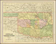
The Neutral Lands and the Race To Construct Railroad Lines from Northern Kansas to Indian Territory
Unrecorded railroad map of Texas, the Southern and Mdiwestern States, published by the Missouri River, Fort Scott & Gulf Railroad and the Leavenworth, Lawrence & Galveston Railroad.
The map; illustrates the routes of these two short-lived railroads, at time when the Neutral Lands (illustrated on the map) were being actively contested and when three different railroad lines were racing to complete lines from Kansas to Indian Territory.
The map is filled with the routes of a number of different lines.
Neutral Lands
The tract once known as the Cherokee Neutral Land -- originally the Osage Neutral Land-- was situated in the southeast corner of Kansas, comprising all of present day Cherokee County, nearly all of Crawford County, and a strip about six miles wide across the southern part of Bourbon County. The tract, some 50 miles long and 25 miles wide, formed the eastern boundary line separating Kansas from Missouri. It was first described in the treaty with the Osage Indians in 1825, when it was intended to serve as a barrier between the Osage tribe and the white settlers, neither of which were to settle thereon, from which fact it took the name of neutral land.
On August 30, 1866, the land was sold to the American Emigrant Company, but it was cancelled 2 days later. On October 9, 1867, the land to James F. Joy, President of the Missouri River, Fort Scott & Gulf Railroad. In March, 1868, the settlers demanded the right to purchase their holdings and the validity of Joy's title to the lands was questioned. The American Emigrant Company had not relinquished its claim and the settlers were alarmed that it would take years of litigation to resolve ownership. A supplemental treaty on April 27, 1868 was passed to "to enable the Secretary of the Interior to collect the proceeds of the sales of said lands and invest the same for the benefit of said Indians, and for the purpose of preventing litigation and of harmonizing the conflicting interests of the said American Emigrant Company and of the said James F. Joy."
Technically, the treaty set aside the Joy sale, but authorized the assignment of the American Emigrant Company's interests to Joy. Eugene F. Ware said: "This was necessary so as to scoop in the land occupied in the meantime by about 3,000 people under the public land law. The law gave a homestead on five years' occupation, but service in the army was counted in, and the soldier who had served three years got title in two years, but with the right to buy the land at $1.25 per acre. The 'treaty' ratified by the senate cut off these rights from all settlers coming in after July 19, 1866."
The supplemental treaty was ratified by the United States Senate on June 6, 1868. On December 18, 1868, notice was given to all persons "who had settled and continued to live on the lands between August 11, 1866, and June 10, 1868, that they might make entry of the lands before a certain time, and thus prevent the sale of the lands to other purchasers." The survey of the Missouri River, Fort Scott & Gulf Railroad was commenced early in 1869, but the settlers organized the "Land League," later known as the "Neutral Land Home-protecting Corps," to resist the encroachments of a corporation under what they believed to be an illegal sale of the public lands. At first, the principal object of the organization was to keep a delegate in Washington to look after the interests of the settlers, but as the railroad company became more aggressive in prosecuting what it conceived to be its legal rights, many acts of violence were committed in the name of the "League." A land office established at Baxter Springs by Joy was raided in February, 1869, and in April, when J. W. Davis attempted to open a land office for the railroad company at Columbus, he was given notice to leave the town. By the last of May the situation had become so threatening that Governor James Harvey issued a proclamation enjoining the people to commit no unlawful acts, and asked General Schofield to send a detachment of United States troops into the Neutral Lands to preserve order, with the troops arriving on June 10, 1869.
Notwithstanding the military presence, the anti-Joy people burned the office of the Girard Press on July 15, 1871. This paper was edited by Dr. Warner, who had been employed by Joy to publish it in the support of his claim. This was the last act of violence.
In the meantime two suits had been filed in the Federal courts -- one against a settler named Holden and the other against Dr. Warner, with the understanding that the title to the lands should be settled by the decision in the two cases. In May, 1870, the circuit court decided in favor of Joy. An appeal to the United States supreme court was then taken, and in November, 1872, that court, in a unanimous opinion, upheld the decision of the lower court. The settlers then bought their lands through Joy, and in February, 1873, the troops were withdrawn.
Missouri River, Fort Scott & Gulf Railroad Company
The Missouri River, Fort Scott & Gulf Railroad was a short-lived line, which first came into existence in 1868.
The Kansas & Neosho Valley Railroad was created in March, 1865, it was taken over by Boston group represented by a man named James F. Joy, president of the Chicago, Burlington, and Quincy Railroad system in August, 1868. The line was first called the Missouri River, Fort Scott & Gulf Railroad Company, but quickly changed its name to the Kansas City, Fort Scott and Gulf Railroad.
Continuing the objectives of the Kansas & Neosho Valley Railroad to build south through Indian Territory. The tracks from Kansas City to Olathe opened in December, 1868, made it to Fort School by December, 1869, and to the border of Kansas and Indian Territory in May, 1870. The total cost to build the line was more than five million dollars. The original design had called for continuing the line all the way to the Gulf of Mexico, but this was not completed as another agreement had been made between the United States and the Missouri, Kansas & Texas Railway.
Leavenworth, Lawrence and Galveston Railroad
The Leavenworth, Lawrence and Galveston Railroad was one of three involved in the famous race from northern Kansas cities to the Indian Territory border (later to became Oklahoma) which took place between 1869 and 1871. The L.L.&G was a distant third in reaching the border at Coffeyville on July 20, 1871.
Financial woes forced reorganization in 1878 and the company emerged as the Lawrence and Galveston Railroad. It was amalgamated with the Kansas City and Santa Fe (Ottawa to Olathe) and the Southern Kansas Railroad (Cherryvale to Independence) and became the Kansas City, Lawrence and Southern Railroad on March 29, 1879. Construction was pushed from Independence through Winfield and Wellington to Harper, with a branch to Hunnewell. The line was sold to the rapidly growing Atchison, Topeka and Santa Fe Railway (AT&SF) due to a rate war between the two companies on Dec. 16, 1880. The name was changed to the Kansas City, Lawrence and Southern Kansas Railroad.
Rarity
The map is apparently unrecorded.
![[ First Modern Map of Texas Coast ] The Western Coast of Louisiana and The Coast of New Leon](https://storage.googleapis.com/raremaps/img/small/38972.jpg)
![[ Missouri named State of Jefferson ] Etats-Unis par A.M. Perrot](https://storage.googleapis.com/raremaps/img/small/99019.jpg)