|
||

|

|
|

|
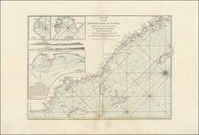
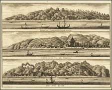
The First Accurate English Sea Chart of Western Sumatra
Finely detailed sea chart of the Southwestern Coast of Sumatra.
The chart extends from Pulau Tanahmasa and the area north of Panang to the Straits of Sunda and Panaitan Island. Includes a large inset map of the Pulau Tikus and the surrounding reef (Ratt Island, off the coast of then Bencoolen-Fort Marlborough and now modern Bengkulu, Indonesia)).
Herbert's char is the first accurate chart of the southwestern coast of Sumatra published in England. At the time, the region was an important British Trading Center, with the East India Company (EIC) based in Bencoolen-Fort Marlborough (modern Bengkulu, Indonesia), the sole permanent British settlement in Southeast Asia at the time the chart was printed.
The chart first appeared in Herbert's A New Directory of the East Indies (London, 1758) and includes significant navigational information, soundings, hazard locations and a fine treatment of the coastline.
South of Panang, adjacent to Ratt Island is the British settlement of Bencoolen and Fort Marlborough (shown in outline), then the British East India Company’s only permanent base in Southeast Asia. Bencoolen was taken over by the EIC in 1685, ostensibly as trading center for the pepper trade. It survived for 140 years as a lone British base in a region dominated by the Dutch East India Company (VOC) and powerful local sultanates. In 1714, to shore up its position in Bencoolen, the EIC constructed Fort Marlborough.
Shortly after the chart was first published, Bencoolen was captured and ransomed by the French admiral, Charles Hector, Comte d’Estaing. The base was soon retuned to the EIC, and remained a British possession until 1825, when it was surrendered to the Netherlands, in exchange for the East India Company taking Malacca (Malaysia).
The English mapmaker William Herbert (1718-95) traveled to India in about 1748 as a purser's clerk. Herbert's cartographic publishing started to take form in the late 1740s, when he set up a map and print shop on London Bridge. In 1758, with the encouragement of the East India Company, he introduced a new pilot guide, A New Directory for the East Indies. Herbert gathered superior sources than those used in Mount & Page's The Third Book, consulting such works as Mannevillette's Neptune Oriental, as well as the navigator William Nicholson and the cartographer Samuel Dunn. He often worked with colleagues, including Jefferys, Sayers, Dury, and Andrews, and is recorded as a seller of the famous Anti-Gallican map. In 1776 he retired, having apparently made a fortune. His business was carried on by Henry Gregory Sr.