All of our maps are authentic antique maps, printed or drawn on or about the date shown in the description. In rare instances when we offer facsimiles, we will specifically describe the map as a later facsimile and include the date of publication. Certificates of Authenticity are included with each item.
Map Maker
Fast, Global Shipping
Last year we shipped over 4,500 antique maps to more than 50 countries. Maps are shipped Monday through Friday year-round. If an order is received before 2 PM PST, we will ship the order that day. If an order is received after that time, we will ship the next day. We ship maps either flat in custom packages or in specially ordered thick tubes. Shipping rates are provided as part of the checkout process.
Description
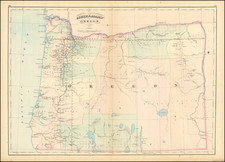
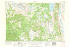
One of the earliest obtainable maps showing the progress of the public surveys in the State of Oregon.
The map includes townships surveyed to 1863, towns, early roads, topographical details, Fort Boise, Mountains and other details.


![[ Oregon ]](https://storage.googleapis.com/raremaps/img/small/96568.jpg)