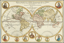
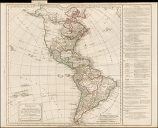
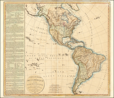
|
||

|

|
|

|
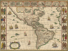
Fine, Rare Map of the Americas from the Dutch Golden Age of Cartography
Fine old-color, richly illustrated example of Hugo Allard’s ca. 1661 map of the Americas, showing California as an island. The separately issued map is quite rare on the market.
The present map shows North, Central, and South America, with part of Greenland to the north and parts of Europe and Africa to the east. Political boundaries are marked in vibrant colors, and many place names are present, especially along the coasts. The northeastern part of North America is identified as New Britain and New France, with New Netherland, Virginia, and Florida (with a distinctive thin peninsula) to the southeast.
To the west of these territories, the large majority of North America, outlined in yellow, is not labeled, and contains fewer features or place names. The Great Lakes are not depicted, although an enlarged St. Lawrence River, labeled L. Contenant, is open on its western end. The northwestern coast of North America is undefined. Below this, California is drawn as an island, a cartographic misconception fairly common in seventeenth-century maps.
A boxy South America is split by great rivers, the Amazon and the Parana (here written as Parama). A large rectangular lake is in the north of the continent, Parime Lacus. The lake was associated with the El Dorado myth and frequently featured on early modern European maps. Tierra del Fuego appears as an island unconnected to a massive southern continent.
Two bays on California’s northern coast, Tolaago and R.de Estiete, and a peninsula on the mainland coast, Agubela de Cato, were perhaps introduced by Nicolas Sanson in his 1636 map. Blaeu is also a source for the northeast of North America. Geographically, the map is identical to Frederick de Wit’s carte a figures map of 1660.
Allard’s innovation is in the lush decorative features that elevate the map. Rather than include the figures in De Wit’s border, Allard has opted for richly illustrated scenes along the entire bottom edge. These depict Europeans interacting with native people. The cartouche in the upper left of the map is enclosed in an ornate red and yellow frame. Images of ships with red flags are depicted in the Atlantic and Pacific Oceans.
This map, as is the case with most of Allard’s work, was separately published, and was not part of a larger publication such as an atlas. It was engraved by Jan van den Velde. Its date of publication cannot be ascertained exactly, but according to Burden, it could not have been published before 1660, when Frederick De Wit’s geographically identical map was published, as Burden believes Allard’s is the later of the two.
California as an island
One of the most striking details of the present map is the island of California. From its first portrayal on a printed map by Diego Gutiérrez, in 1562, California was shown as part of North America by mapmakers, including Gerardus Mercator and Ortelius. In the 1620s, however, it began to appear as an island in several sources.
This was most likely the result of a reading of the travel account of Sebastian Vizcaino, who had been sent north up the shore of California in 1602. A Carmelite friar who accompanied him later described the land as an island, a description first published in Juan Torquemada’s Monarquia Indiana (1613) with the island details curtailed somewhat. The friar, Fray Antonio de la Ascension, also wrote a Relacion breve of his geographic ideas around 1620. The ideas spread about New Spain and, eventually, most likely via Dutch mariners and perhaps thanks to stolen charts, to the rest of Europe.
By the 1620s, many mapmakers chose to depict the peninsula as an island. These included Henricus Hondius, who published the first atlas map to focus solely on North America with the island prominently featured in 1636. Hondius borrowed his outline of California from another widely distributed map, that of Henry Briggs and printed in Samuel Purchas’ Hakluytus Posthumus or Purchas his Pilgrimes (1625). Other prominent practitioners like John Speed and Nicolas Sanson also adopted the new island and the practice became commonplace.
Father Eusebio Kino initially followed along with this theory, but after extensive travels in what is now California, Arizona, and northern Mexico, he concluded that the island was actually a peninsula. Even after Kino published a map based on his travels refuting the claim (Paris, 1705), California as an island remained a fixture until the mid-eighteenth century.
The Dutch Golden Age and cartography
In the late 1500s, seven Dutch provinces in the northern Netherlands achieved independence from Spain and formed the Dutch Republic. Though the Dutch state was small and ruled by a decentralized system of control, it managed to cultivate a powerful seventeenth-century sea empire based on trade. This era became known as the Dutch Golden Age.
Due in large part to their powerful trade empire, the Dutch became known for cartography in the seventeenth century. Their publishing houses produced the highest quality work in Europe, particularly those maps and charts of foreign lands, and Dutch map-making set the bar for cartographic accuracy and artistry into the early-eighteenth century.
Some of the most well-known cartographers worked in Amsterdam during this period. Perhaps the most famous of these was the Blaeu family. Willem Janszoon Blaeu, set up shop in Amsterdam. His son, Joan, succeeded him upon his death in 1638, continuing in his father’s position as Hydrographer to the Dutch East India Company and selling maps to the public. The Blaeu map presses, located near Amsterdam’s Dam Square, were the largest the world had ever seen to that time. When the printing press warehouse burned in 1672, it signaled the end of the Dutch Golden Age, in cartography at least.
Rarity
Whereas Blaeu maps are the most famous of the Dutch Golden Age, many other mapmakers were also issuing striking work at the time. Allard is one of these, and his works remain rare on the market and are in only a few institutional collections.
The Antique Map Price Record locates only one copy (Jonathan Potter, 2006) on the market in recent years. The Bibliotheque Nationale in Paris has an uncolored example.
Hugo (or Huych) Allard (or Allardt) (1627–1684 or '91) was a draughtsman, engraver, and painter during the Dutch Golden Age of cartography. Based in Tournai and Amsterdam, he was the founder of a prominent family of Dutch mapmakers, publishers, and print sellers. Allard set up his cartography business around 1645, and his first works were mostly reissues of earlier maps. Although not as prominent as the Blaeu family or Henricus Hondius and Jan Janssonius, Hugo Allard’s work, from about 1640 to 1680, is considered to be just as fine in quality. His output was relatively small, and his maps were mostly published as loose, separate issues, but they were well-designed and finely engraved. After Allard’s death, he left his business to his son, Carel. There is some confusion about when he died; some sources state 1684, others say 1691.
![[ Sea of the West ] L'Amerique divisee en ses principaux Etats . . .](https://storage.googleapis.com/raremaps/img/small/103460.jpg)
![America noviter delineata [ Heightened with Gold Leaf ]](https://storage.googleapis.com/raremaps/img/small/71040.jpg)