|
||

|

|
|

|
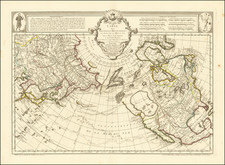
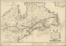
Scare early map of Alaska by Peterman, from one of his geographical reports. For a number of years in the mid to late 19th Century, Petermann's Geographische Mittheilungen provided a compilation of contemporary explorations of the various nations throughout the world, often providing the earliest commercially available maps of the newly explored regions. This map of Alaska and the Northwest surpasses contemporary atlas maps in providing the most up to date regional information, including Russian Forts, elevations of moutains and lots of additonal information from Russian, American and British Sources, most recently W.H. Dall's Coast Survey work.
August Heinrich Petermann (1822-1878) is a renowned German cartographer of the nineteenth century. Petermann studied cartography at the Geographical Art-School in Potsdam before traveling to Edinburgh to work with Dr. A. Keith Johnston on an English edition of Berghaus’ Physical Atlas. Two years later he moved to London, where he made maps and advised exploratory expeditions as they set off to explore the interior of Africa and the Arctic.
In 1854, Petermann returned to Germany to be Director of the Geographical Institute of Justus Perthes in Gotha. There, he was the editor of the Geographische Mittheilungen and Stieler’s Handatlas. The Royal Geographical Society of London awarded him their Gold Medal in 1860. He continued his interest in exploration in Germany, fundraising for the German Exploring Expeditions of 1868 and 1869-70, which sought an open Arctic sea. Tragically, he committed suicide in 1878.
![[The First Maps Printed Color] Cartes en Couleur des Lieux Sujets aux tremblements de Terre Dans toutes les parties du Monde Selon le Sisteme de l’impulsion Solaire](https://storage.googleapis.com/raremaps/img/small/52293op.jpg)