|
||

|

|
|

|
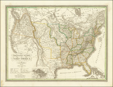
The Most Important American Map of the 18th Century
Fine example of the French edition of Mitchell's seminal map of the Eastern part of North America.
Mitchell's is regarded as perhaps the single most important American map of the 18th Century, and was used as a source reference for the resolution of virtually every treaty and boundary dispute from the French & Indian War until the end of the 19th Century. The present example was published by the French cartographer Georges Le Rouge.
Mitchell's map would become the primary political treaty map in American history Twenty-one variant states and editions of the map appeared between 1755 and 1781. John Jay used a copy of the third edition during the negotiations of what would become the Treaty of Paris (1783). Thomas Jefferson recommended that Nicholas King use Mitchell's map in preparing a new map for Meriwether Lewis, saying: "it was made with great care we know from what is laid down in those western parts with which we have lately become acquainted." To get even a partial sense of the historic uses to which the map was put, we quote Col. Lawrence Martin, the second chief of the Library of Congress Geography and Map Division :
[Mitchell's map] is thought to have been in use in the British House of Commons during the debate on the Quebec Act of 1774; it is known to have hung in the halls of Congress in 1802 and several times subsequently. It was used ... in the discussions of British land grants in the Ohio and Mississippi valleys, and in scores of controversies involving the boundary lines existing at the time of its publication. Great Britain and the United States agreed to its official status in the Convention of September 29, 1827.... it exerted substantial influence in the negotiation and ratification of the Webster-Ashburton Treaty of 1842, and serious argument was based upon it by Great Britain before the Court of Arbitration at The Hague in 1910 in connection with the North Atlantic Coast Fisheries Arbitration. It was submitted in evidence before the Law Lords of the British Privy Council in 1926 in the appeal of Price Brothers & Company, Limited, from a judgment of the supreme court of Canada, and in 1926-27 in the Canada-Newfoundland (Labrador) boundary case. It was used as evidence before the Supreme Court of the United States in the Wisconsin-Michigan boundary case, in 1926-27 in the Great Lakes level case, and in 1932 in the New Jersey-Delaware boundary case."
Watch Geography Geek's Video on the Importance of the Mitchell Map:
The Mitchell Map
John Mitchell (1711-1768), a respected British physician, botanist, chemist, biologist, and surveyor, lived for a time in Virginia, but returned to England in 1746, where he remained until his death. Mitchell initially conceived of his map of North America in order to present to the British public with a single large format image of all the colonies, in order to illustrate the extent of the French threat to the British claims in North America. Mitchell completed his first draft of the map in 1750. However, because Mitchell was limited to publicly available sources of information, this initial effort was rather crude, even in Mitchell's own opinion. As word of Mitchell's work spread, the Board of Trade and Plantations retained Mitchell to make a new map, using the official manuscript and printed maps and reports in the Board's possession, including maps by Fry and Jefferson, Christopher Gist, George Washington, John Barnwell, and others. The Board also instructed all the colonial governors to send detailed maps and boundary information for Mitchell's use.
Mitchell's map was first published by Andrew Millar in 1755, the year before war broke out with the French. The map is decidedly pro-English in its interpretation of the various boundaries and geographical information depicted on the map, as would be expected for what amounted to thinly veiled pre-war propaganda. In addition to the geographical detail shown on the map, Mitchell included many annotations describing the extent of British and French settlements. He also submitted a report to the Board in 1752, listing the French encroachments and his ideas to encourage British settlement west of the Appalachian Mountains, as a means of combating French influence in the region. Mitchell is also the likely author of The Contest in America Between Great Britain and France by an Impartial Hand (1756), which addresses the same topic.
The first edition of the map was quickly followed by a second edition in 1757, which adds two large blocks of text in the Atlantic Ocean, providing Mitchell's data sources and an account of how he compiled the numerous provincial maps to create this map. After Mitchell's death in 1768, the plates were purchased by Jefferys & Faden, who revised the map and issued a third edition in 1773-74. Faden published a fourth edition in 1775, with the title changed to A Map of the British Colonies in North America ....
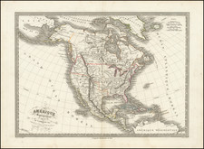
Mitchell's map shows the British Colonial claims of Virginia, both Carolinas, and Georgia extending beyond the Mississippi to the Pacific Ocean. In the West, Mitchell's treatment of the lower Missouri is a vast improvement over earlier maps. Regarding the source of the Missouri, Mitchell notes "Missouri river is reckoned to run westward to the Mountains of New Mexico, as far as the Ohio does eastward," reflecting his belief in symmetrical geography. Mitchell correctly shows the northern branch of the Missouri to be the main branch of the river, although his estimate of the latitude of the river's source is inaccurate. Nonetheless, the information Mitchell's map provided led Meriwether Lewis up the Marias River to determine the northern reaches of the Missouri River basin.
Rarity
All editions of Mitchell's map are scarce, although the rarest are without question the earliest 3 editions of Mitchell's map (1755-1756) and the two editions published by Coven & Mortier.
This Le Rouge edition is a well executed copy of the Mitchell's original map and the only full size copy of the Mitchell map which is reasonably obtainable by collectors, the Covens & Mortier having appeared only very infrequently on the market in the past 20 years.
![The United States of America Confirmed By Treaty 1783 [shows Franklinia]](https://storage.googleapis.com/raremaps/img/small/84491.jpg)