|
||

|

|
|

|
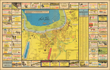
Rare early map showing the proposed route of the Central Pacific Railroad, during a relatively early period of its construction.
The present map is one of the earliest maps focusing on the route of the Central Pacific, which we have seen, and was clearly intended to illustrate some sort of report either on the progress of the route or access to the mining regions in Nevada from the West Coast. One fascinating place name which appears on the map is "Ostar City," between Humboldt and Humboldt Wells, Nevada. While it almost certainly shows because it was an intended station on the route, we can find no record of an Ostar, or Ostar City, in Nevada.
The map shows the route extending from the West to Virginia Station, just to the east of Cisco, California. The route reached Cisco on December 3, 1866 and Virginia Station on May 10, 1867. The map shows the Utah-Nevada Border as it existed between 1862 and 1866.
Humboldt (Humboldt House or Humboldt Station) was the point intended as a drop point for miners headed to and from Humboldt City, Prince Royal, and the central Nevada mines in the vicinity. In September, 1866, it became a stage stop for historic William (Hill) Beachey Railroad Stage Lines. As the Central Pacific Railroad advanced from eastern California, it reached Humboldt House about September 15, 1868. The name "Humboldt Wells" refers to a point which had been important to overland travelers even before the Railroad, as it was an important watering point on the California Emigrant Trail. It became the first on the Central Pacific route, and was completed in September 1869 and would become the town of Wells, Nevada in 1873.
The map also locates Great Salt Lake City and Ft. Bridger, although neither is on the Railroad Route. Further to the west, the railroad splits into the Union Pacific (bound for Council Bluffs), and the Union Pacific Kansas Branch, which passes through Denver City, on its way to St. Louis.
Pamphlet
The full title is Railroad Communication Across The Continent, With an Account of the Central Pacific Railroad, of California: A Description of the Route, The Progress and Character of the Work, Its Resources, Business and Prospects With the Foundation and Advantages of Its First Mortgage Bonds. An earlier edition of the pamphlet, which appears to be the more common edition, was published in New York in May, 1867. The first edition (with a slightly different title) included a folding map published by the Colton firm, which is different than the present map. This edition includes 32 pages of text and a printed map.
Early piece concerning the Central Pacific Railroad, which later became the Southern Pacific. The pamphlet offers an interesting description of the transcontinental railroad as it was being built, the difficulties to be faced (such as crossing the Sierra Nevada), the expected cost when completed, likely profit to investors, etc.
There appear to be at least three variants of this pamphlet, dated February, May and September 1868.
Rarity
This state of the pamphlet is scarce, with no recorded examples appearing at auction in the past 30 years.
![[California and Nevada] (Names Bigler Lake or Tahoe)](https://storage.googleapis.com/raremaps/img/small/94197.jpg)