|
||

|

|
|

|
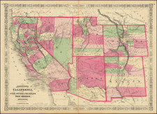
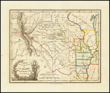
The First Great Map of Kansas Territory
Fine large map of the soon to be "settled part" of Kansas Territory, drawn from the work of C.P. Wiggin. and lithographed by William Schuchman & Bro in Pittsburgh.
The map illustrates the earliest settlements in Kansas, which are shown primarily along the Missouri River north of Kansas City and on the Kansas River and Grasshopper Creek. As the map progresses further west, the details and settlements become increasingly sparse, with Council Grove on the Santa Fe Trail in the Kansas Reservation being the western most place located on the map.
The Mac Lean & Lawrence map is the first to minutely depict the overland routes from St. Joseph, Leavenworth, Atchison, Westport, etc. over both the Oregon Trail and the Santa Fe Trail. It also offers a fine treatment of the original county boundaries and Indian Reservations in Kansas Territory, which had been created in May 1854.
The map brings together the three elements which dominate the early history of Kansas, (1) the claims of the American Indians in the region (both native and relocated into the region) (2) westward expansion into the region following the passage of the Kansas-Nebraska Act of 1854, which repealed the Missouri Compromise of 1820 and allowed the settlers of Kansas Territory to determine by popular sovereignty whether Kansas would be a free state or a slave state and (3) the first depiction on a large scale of the progress of the General Land Office Surveys, which would divide the lands for settlement and speculation over the coming years.
At the top right, the map includes a brief explanation of the means by which land was subdivided for purchase -- the 36 sections which made up the basic building blocks of the Township Surveys, which as noted below the title was actively being undertaken from the Surveyor General's office in Lecompton, Kansas Territory. In describing this map, Baughman notes:
Before Kansas could legally acquire title to public lands the federal government had to clear the way. The Indian title had to be extinguished and public surveys carried out . . . . No mapping has ever so profoundly affected the physical appearance of land as did the township surveying method. . . . Visibly the land is divided into endlessly repeated squares, reflecting the pattern of survey and sale. Road-building and farming generally follow the original patterns marked out by the General Land office . . . Leavenworth City [shown on the map], the oldest town in Kansas, was not depicted on public survey maps until . . . 1856. . . . Perhaps the omission was intentional because the men who laid it out on June 12, 1854, did so on Delaware Indian land, no clear titles being obtainable until more than a year later.”
The map identifies L.A. Mac Lean as the Chief Clerk of the General Land Office in Kansas. No mention of Lawrence appears on the map.