


|
||

|

|
|

|
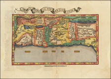
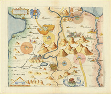
Extremely rare map of the Holy Land based upon the writings in the Old Testament, published by Jean Boisseau and engraved by Jean Picart in Paris.
The map includes descriptive text at the bottom entitled: Briefue Description de la Terre Saincte.
The map illustrates the Holy Land with east at the top, in a style popularized by Van Adrichem, which would become popular in the 17th Century. The map illustrates the Exodus of the Jews from Egypt, led by Moses, with the parting of the Red Sea and 42 years of wandering in the Desert.
The map illustrates the Tribes of Israel, cities, rivers, mountains and other points of interest.
Rarity
The map is extremely rare on the market. OCLC locates only the example in the British Library, National Library of Israel and Bibliotheque National de France.
![[Tel Aviv - Yafo] A View of the City and Port of Joppa at Present Called Jaffa. According to our modern Travellers](https://storage.googleapis.com/raremaps/img/small/89073.jpg)
![[ Mount of Olives ] Afbeelding Van Den Olyfberg. Volgens de hedendaagsche Reizigers](https://storage.googleapis.com/raremaps/img/small/101645.jpg)
![Carte De La Syrie [Shows Cyprus and the Holy Land!]](https://storage.googleapis.com/raremaps/img/small/61321.jpg)