|
||

|

|
|

|
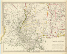
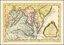
The Southern British Colonies at the Outset of the American Revolution
Separately issued section of the Italian edition of John Mitchell's landmark map of the British Colonies in North America .
A marvelous regional map which shows the area bounded by the Mississippi River, the Gulf Coast, and the Southern Appalachians, drawn from Mitchell's monumental work. This map first appeared in Antonio Zatta's four volume Atlante Novissimo published from 1775-1785, which contained 218 maps. The map is in fact one sheet (sheet X) of Zatta's 20 sheet map of North America , Le Colonie Unite dell' America Settentrle.
John Mitchell's A Map of the British and French Dominions in North America … is the basis for Zatta's work and is widely regarded as the single most important map of North America published during the 18th Century. The Mitchell map graphically illustrates the various territorial claims made by the competing British and French empires and also the various British colonies, and is the most comprehensive map of North America produced prior to the French & Indian War. Zatta's version of Mitchell is not an exact or complete copy: the Zatta maps do not cover the far western portions of Mitchell's map and many geographical changes are introduced. Zatta also included updated legends (in Italian), with notations concerning the Revolutionary War. To view the Mitchell map, follow this link: /gallery/detail/17643
This is a great regional map that marks New Orleans and details the Gulf Coast to the Florida panhandle, as well as the valley of the Mississippi River north above "Akansa" and "Po. Ozier." It also depicts Mobile Bay and the course of the "Albama" River and its tributaries. The map extends to show the region of "Capo S. Biagio" and the course of the Apalachicola River .
The map includes many details regarding the local Indians: "Apalachesi," "Chactaw," "Criki Indiani," and "Nattchees" among others. The quality of the lands is noted. Several early roads are shown, complete with mileage notations, including "Strada del Coll Welk," the prominent trading route in the north which nearly reaches the Mississippi River . A number of forts are depicted and crossed swords locate various battles. One of the most interesting and curious 18th Century maps of the Gulf Coast Region.
Antonio Zatta (fl. 1757-1797) was a prominent Italian editor, cartographer, and publisher. Little is known about his life beyond his many surviving published works. It is possible that he was born as early as 1722 and lived as late as 1804. He lived in Venice and his work flourished between 1757 and 1797. He is best known for his atlas, Atlante Novissimo (1779-1785), and for his prolific output of prints and books that were both precisely made and aesthetically pleasing. Zatta clearly had a large network from which to draw information; this is how he was able to publish the first glimpse of the islands visited by Captain Cook in the Atlante Novissimo. Zatta also published books of plays and architecture.
![Dominia Anglorum in America Septentrionali Specialibus Mappis Londini primum a Mollio… [4 maps--New England; Chesapeake, Georgia, Carolinas & Florida; and Nova Scotia…]](https://storage.googleapis.com/raremaps/img/small/60331.jpg)