This item has been sold, but you can enter your email address to be notified if another example becomes available.


|
||

|

|
|

|
Stock# 64890
Description
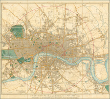
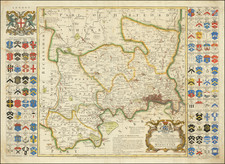
A detailed antique engraved plan of London published in London 1791.
The map appeared in Kearsleys’ Stranger’s Guide, or Companion through London and Westminster, and the Country Round: Containing a Description of the Situation, Antiquity, and Curiosities of Every Place, within the Circuit of Fourteen Miles, Together with a Map of the Surrounding Country, and a Plan of the Cities of London and Westminster, and the Borough of Southwark. Printed for and Sold by C. and G. Kearsley, Fleet-Street. Circa 1791.
Reference
Howgego 197
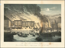
![(London) [Eyewitness Watercolor Drawing of the Burning of Her Majesty's Theatre, Covent Garden, on December 6, 1867.]](https://storage.googleapis.com/raremaps/img/small/90852.jpg)