|
||

|

|
|

|
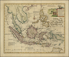
Extremely rare English sea chart, covering a portion of Southern Thailand and northwestern Sumatra.
At the top right, the map provides a detailed image of the area around Junk Seilon Island, now known as Phuket, along with the adjacent Phang Nga Bay and coastline of Krabi Province.
The primary map covers a significant portion of the West Coast of Sumatra, centered on Pini Island and extending well to the south of Padang.
A note at the right of the map states:
The large Islands which lie off this part of Sumatra are not incerted till a more particular Plan can be procured. This Chart being drawn chiefly for those who have occasion to Sail very near it. The Lines shew the Tracks which Ships usually make.
Herbert’s chart of the region is the first broadly accurate British sea chart of this important region, marking a milestone in the revival of hydrography sponsored by the East India Company.
The English mapmaker William Herbert (1718-95) traveled to India in about 1748 as a purser's clerk. Back home in the early 1750s, he set up a map and print shop on London Bridge, and in 1758, with the encouragement of the East India Company, he introduced a new pilot guide, the New Directory for the East Indies. Herbert gathered superior sources than those used in Mount & Page's The Third Book, consulting such works as Mannevillette's Neptune Oriental, as well as the navigator William Nicholson and the cartographer Samuel Dunn.
Rarity
The chart is extemely rare. This is the first example we have ever seen on the market.
The English mapmaker William Herbert (1718-95) traveled to India in about 1748 as a purser's clerk. Herbert's cartographic publishing started to take form in the late 1740s, when he set up a map and print shop on London Bridge. In 1758, with the encouragement of the East India Company, he introduced a new pilot guide, A New Directory for the East Indies. Herbert gathered superior sources than those used in Mount & Page's The Third Book, consulting such works as Mannevillette's Neptune Oriental, as well as the navigator William Nicholson and the cartographer Samuel Dunn. He often worked with colleagues, including Jefferys, Sayers, Dury, and Andrews, and is recorded as a seller of the famous Anti-Gallican map. In 1776 he retired, having apparently made a fortune. His business was carried on by Henry Gregory Sr.

![[Elephants & Tourism] Chaine Des Elephants Plateau Du Bo'kor [Southeastern Cambodia]](https://storage.googleapis.com/raremaps/img/small/64472.jpg)