|
||

|

|
|

|
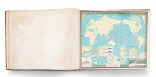
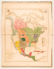
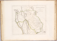
Four volumes. Folio. [18], 50 pages and 1 frontispiece and 45 (out of 46) double-page geographical maps; 1 frontispiece and 48 (out of 53) double-page geographical maps; 1 frontispiece, 1 index leaf, 54 double-page geographical maps; 1 frontispiece and 61 (of 63) double-page geographical maps. With a total of 4 chalcographic frontispieces including 1 double-page and 208 (out of 216) tables in coeval coloring engraved in double-page copper by Giuliano Zuliani on drawings by Giovanni Pitteri. Exemplary copy of an index sheet, the sheet for the Associates and 8 double-page maps (the Map of the universe; The Bishopric of Munster; The kingdoms of Sweden, Denmark, and Norway; The Palatinate of Mazovia; The Palatinate of Posnania; Croatia, Bosnia; Indie fourth sheet; America) and with a frontispiece of the II tome used in place of the IV and counterfeit in pen (hence the date 1784 instead of 1785).
The most beautiful and complete atlas published in Italy in the eighteenth century, and the most famous work of Zatta. The "new Atlas", as specified in the title, is enhanced by the discoveries made by the most famous and most recent geographers: among the most significant innovations there is the appearance of the new islands discovered in the Pacific Ocean by James Cook and the first Italian map of New Zealand.
Antonio Zatta (fl. 1757-1797) was a prominent Italian editor, cartographer, and publisher. Little is known about his life beyond his many surviving published works. It is possible that he was born as early as 1722 and lived as late as 1804. He lived in Venice and his work flourished between 1757 and 1797. He is best known for his atlas, Atlante Novissimo (1779-1785), and for his prolific output of prints and books that were both precisely made and aesthetically pleasing. Zatta clearly had a large network from which to draw information; this is how he was able to publish the first glimpse of the islands visited by Captain Cook in the Atlante Novissimo. Zatta also published books of plays and architecture.
![(Atlas of France) Les Cartes Generales de Toutes les Provinces de France Reveues corrigees & augmentees par le Sr. Tassin Geographe ordinaire de sa Mageste [The General Maps of All the Provinces of France, Reviewed, Corrected, and Expanded by Mr. Tassin, Geographer to His Majesty.]](https://storage.googleapis.com/raremaps/img/small/95902.jpg)