|
||

|

|
|

|
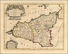
With a Large Image of a Volcanic Eruption at Mt. Aetna
Finely detailed map of island of Sicily, with a large inset of Malta, published by Guillaume De L'Isle in Paris.
The map extends to include the Aeolian Islands, which are here called the Lipari Islands. It is filled with a wealth of interesting detail including roads, forests, fortresses, churches, abbeys, ancient ruins, aqueducts, and towns.
The most prominent feature of the map is the large active volcano, Mt. Etna. The inset at lower left focuses on the islands of Malta and Goze. The inset has its own scale and significant buildings and fortifications are listed.
Guillaume De L'Isle (1675-1726) is probably the greatest figure in French cartography. Having learned geography from his father Claude, by the age of eight or nine he could draw maps to demonstrate ancient history. He studied mathematics and astronomy under Cassini, from whom he received a superb grounding in scientific cartography—the hallmark of his work. His first atlas was published in ca. 1700. In 1702 he was elected a member of the Academie Royale des Sciences and in 1718 he became Premier Geographe du Roi.
De L'Isle's work was important as marking a transition from the maps of the Dutch school, which were highly decorative and artistically-orientated, to a more scientific approach. He reduced the importance given to the decorative elements in maps, and emphasized the scientific base on which they were constructed. His maps of the newly explored parts of the world reflect the most up-to-date information available and did not contain fanciful detail in the absence of solid information. It can be fairly said that he was truly the father of the modern school of cartography at the commercial level.
De L’Isle also played a prominent part in the recalculation of latitude and longitude, based on the most recent celestial observations. His major contribution was in collating and incorporating this latitudinal and longitudinal information in his maps, setting a new standard of accuracy, quickly followed by many of his contemporaries. Guillaume De L’Isle’s work was widely copied by other mapmakers of the period, including Chatelain, Covens & Mortier, and Albrizzi.
![Valetta, the Capital of the Island of Malta [with] Balearic Islands [and] Corsica and Sardinia](https://storage.googleapis.com/raremaps/img/small/87300.jpg)
![Malte [Malta | Valetta]](https://storage.googleapis.com/raremaps/img/small/79497.jpg)