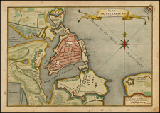
|
||

|

|
|

|
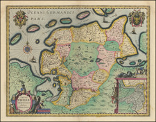
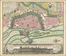
Fine original color example of Blaeu's map of the German Bishopric of Osnabrück.
The large strapwork title cartouche incorporates a fine view of the city with its many steeples dominating the sky-line. At lower right is an inset of Reckenberg.
Further embellished with a coat of arms, with small provincial armorials and a smaller cartouche.
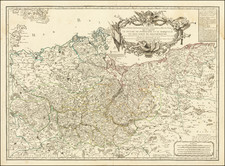
During the first half of the 17th century, the Bishopric of Osnabrück (Osnabrugensis Episcopatus), stood as a prominent ecclesiastical principality in the Holy Roman Empire, located in the lower Saxony region of Germany. The Bishopric was not only home to the principal city of Osnabrück but also to other significant towns like Quakenbrück, Melle, and Iburg. These towns, along with vital rivers such as the Hase and the Vechte, were central to the region's trade and transport.
Leadership within the Bishopric was under the aegis of Prince-Bishops, combining spiritual and temporal authority. A notable leader during this era was Franz Wilhelm von Wartenberg, appointed in 1625, who endeavored to reassert Catholic dominance amid the Reformation's prevailing winds. The Thirty Years' War profoundly impacted Osnabrück, situating it both as a battleground and a diplomatic hub. Its strategic and religious significance drew various European powers' attention, ensnaring it in the wider conflict.
The city of Osnabrück emerged as a site of immense importance, especially as negotiations for the Peace of Westphalia were held there in 1648, marking a pivotal moment in European history. These negotiations, aiming to conclude the Thirty Years' War, underscored Osnabrück's role in shaping the future of Europe. Culturally, the Bishopric was a nexus of Catholic and Protestant influences, reflecting the era's religious conflicts. The Counter-Reformation, championed by figures like von Wartenberg, fostered a resurgence of Catholic art and architecture, yet Protestant elements persisted, particularly in more rural areas.
Willem Janszoon Blaeu (1571-1638) was a prominent Dutch geographer and publisher. Born the son of a herring merchant, Blaeu chose not fish but mathematics and astronomy for his focus. He studied with the famous Danish astronomer Tycho Brahe, with whom he honed his instrument and globe making skills. Blaeu set up shop in Amsterdam, where he sold instruments and globes, published maps, and edited the works of intellectuals like Descartes and Hugo Grotius. In 1635, he released his atlas, Theatrum Orbis Terrarum, sive, Atlas novus.
Willem died in 1638. He had two sons, Cornelis (1610-1648) and Joan (1596-1673). Joan trained as a lawyer, but joined his father’s business rather than practice. After his father’s death, the brothers took over their father’s shop and Joan took on his work as hydrographer to the Dutch East India Company. Later in life, Joan would modify and greatly expand his father’s Atlas novus, eventually releasing his masterpiece, the Atlas maior, between 1662 and 1672.