This item has been sold, but you can enter your email address to be notified if another example becomes available.


|
||

|

|
|

|
Stock# 6430
Description
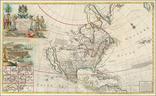
Highly detailed map of North America, showing the region at the time of the Louisiana Purchase. Nice incomplete NW Coast of America shows post Vancouver information. Massive Lake Teguayo appears, with feebile effort to keep Quivira on the map. Three Volcanoes are noted near Mendocino. The Colorado River is the Martyrs River. Very incomplete knowledge of the Transmississippi West, shortly before Lewis & Clark. A bit of darkening along one fold, but otherwise a nice example.
![(North America) ФИЗИЧЕСКАЯ КАРТА СEВЕРНОЙ АМЕРИКИ. [Physical Map of North America]](https://storage.googleapis.com/raremaps/img/small/90262.jpg)
![[ First Map to Name The United States ] L'Amerique septentrionale ou se remarquent les Etats Unis . . . 1779](https://storage.googleapis.com/raremaps/img/small/94192.jpg)
![Amerique Septentrionale divisee en Ses Principales parties . . . . 1674 [Rare First State]](https://storage.googleapis.com/raremaps/img/small/99317.jpg)