|
||

|

|
|

|
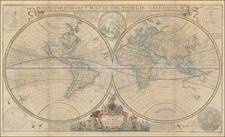
Attractive example of J.B. Nolin's map of the World, with 10 different hemispheric projections.
The map shows California as an Island, no northwest coast of America, and incomplete coastlines or New Zealand and Australia. The mythical Terres Australes et Inconnues is still shown.
The present map was first issued in 1690, with the date in the title and areas between the two hemispheres at the center left blank, with Nolin's address given as "Quay de l'Horologe des Palais proche la Rue de Harlay a l'Enseigne de la Place Des Victoires." The second edition includes a different address ". . . proche la Pont-Neuf. . . " and includes a dedication to Louis Phelippeaux De Pontchartrin, Chancelier de France". This third edition bears the date of 1742 and the address of rue Saint Jacques.
Jean Baptiste Nolin (c.1657-1708) was the leading French cartographer of the late sixteenth-century. Fulfilling various royal commissions for Louis XIV, Nolin had privileged access to official French geographical sources. He notably maintained a close and highly lucrative association with the great Venetian cartographer Vincenzo Maria Coronelli.
Jean-Baptiste Nolin (ca. 1657-1708) was a French engraver who worked at the turn of the eighteenth century. Initially trained by Francois de Poilly, his artistic skills caught the eye of Vincenzo Coronelli when the latter was working in France. Coronelli encouraged the young Nolin to engrave his own maps, which he began to do.
Whereas Nolin was a skilled engraver, he was not an original geographer. He also had a flair for business, adopting monikers like the Geographer to the Duke of Orelans and Engerver to King XIV. He, like many of his contemporaries, borrowed liberally from existing maps. In Nolin’s case, he depended especially on the works of Coronelli and Jean-Nicholas de Tralage, the Sieur de Tillemon. This practice eventually caught Nolin in one of the largest geography scandals of the eighteenth century.
In 1700, Nolin published a large world map which was seen by Claude Delisle, father of the premier mapmaker of his age, Guillaume Delisle. Claude recognized Nolin’s map as being based in part on his son’s work. Guillaume had been working on a manuscript globe for Louis Boucherat, the chancellor of France, with exclusive information about the shape of California and the mouth of the Mississippi River. This information was printed on Nolin’s map. The court ruled in the Delisles’ favor after six years. Nolin had to stop producing that map, but he continued to make others.
Calling Nolin a plagiarist is unfair, as he was engaged in a practice that practically every geographer adopted at the time. Sources were few and copyright laws weak or nonexistent. Nolin’s maps are engraved with considerable skill and are aesthetically engaging.
Nolin’s son, also Jean-Baptiste (1686-1762), continued his father’s business.

![[ The Lost Paulus Ageminius Casket Map ]](https://storage.googleapis.com/raremaps/img/small/97534.jpg)